

|
|
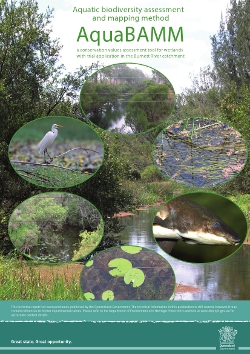
Aquatic Conservation Assessments (ACA) and AquaBAMMAquatic Conservation Assessments (ACAs) are designed with the sole intent of identifying conservation values of wetlands at a user-defined scale. They do not consider social or economic values. The Aquatic Biodiversity Assessment Mapping Method (AquaBAMM) used to develop the ACAs. AquaBAMM identifies relative wetland conservation values within a specified area—usually a catchment— using criteria, indicators and measures (CIM) that are based on a large body of national and international literature. The method was first trialled in the Burnett River catchment. Find out more about accessing the data and reports on the get mapping help page. The riverine and non-riverine data and reporting (information on specific environmental values, by location) may be accessed through WetlandMaps. Information on specific environmental values, by location, is also available via Environmental reports online. See the AquaBAMM information sheet or email biodiversity.planning♲des.qld.gov.au
Quick facts

Aquatic Conservation Assessments (ACA) and AquaBAMMThe Aquatic Biodiversity Assessment and Mapping Method (AquaBAMM) is a comprehensive method that identifies relative wetland conservation values within a specified study area (usually a catchment). AquaBAMM is used to produce an aquatic conservation assessment (ACA) of wetlands within that area. The results provide a powerful decision support tool that can be comprehensively interrogated through a Geographic Information System (GIS) platform.Freshwater ACAs have been completed for all of Queensland (see table below). In 2019, an ACA was completed for the subtidal and intertidal environments extending from just south of the mouth of Baffle Creek to north of the Fitzroy Rivers. In 2022, the Queensland Department of Environment and Science (now the Department of Environment, Science and Innovation) commenced an update of the Queensland Great Barrier Reef connecting catchments (GBRCC) Aquatic Conservation Assessment (ACA) using the Aquatic Biodiversity Assessment and Mapping Methodology (AquaBAMM). For more information, see the Information Sheet. ACAs provide a powerful decision-support tool that can be interrogated through online mapping or GIS platforms. Results can be used in a wide range of applications including, but not limited to:
1 The Burnett River Riverine ACA is superseded by the Wide Bay-Burnett riverine ACA, which includes coverage of the Burnett River catchment. The Burnett River Riverine ACA remains displayed in the table above due being the first ACA study. Wetland on-line education modules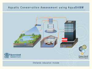 A series of on-line education modules, including Aquatic Conservation Assessment using AquaBAMM, is available for people who wish to learn more about wetlands. The modules should be used in conjunction with the information on this website. Pages under this sectionLast updated: 23 September 2020 This page should be cited as: Department of Environment, Science and Innovation, Queensland (2020) Aquatic Conservation Assessments (ACA) and AquaBAMM, WetlandInfo website, accessed 18 March 2024. Available at: https://wetlandinfo.des.qld.gov.au/wetlands/assessment/assessment-methods/aca/ |
||||||||||||||||||||||||||||||||||||||||||||||||||||||||||
Site footer

 — Department of Environment, Science and Innovation