

|
|
WetlandUpdate November 2014Wetlands of the Great Barrier Reef catchments brochureThe Wetlands of the Great Barrier Reef catchments brochure promotes the values of the wetlands in the cathments of the Great Barrier Reef. It recognises wetlands as part of the broader landscape connecting catchments to the Reef. It promotes wise management of wetlands vital for protecting the world recognised values of the Great Barrier Reef. As many wetlands are located on private property, the brochure encourages a ‘working in partnership with landowners’ theme to achieve best outcomes. The Great Barrier Reef—Our wetlands videoThe Great Barrier Reef—Our wetlands video, introduced by Andrew Powell, Minister for Environment and Heritage Protection, highlights the importance of wetlands in the catchments of the Great Barrier Reef. Currawinya Lakes Ramsar site informationCurrawinya Lakes Ramsar site information has been updated including:
Wetland plants of the Townsville—Burdekin floodplainWetland Plants of the Townsville–Burdekin Floodplain is a user friendly illustrated field guide that offers comprehensive information on the wetland plants of the area. The useful guide was published by the Lower Burdekin Landcare Association in partnership with the Burdekin Shire Council, Department of Agriculture, Fisheries and Forestry (DAFF) through the Queensland Wetlands Program, NQ Dry Tropics Regional Landcare Facilitator Program, Wilmar Sugar and the RPS Group Townsville. New case studiesManaging water for the farm and environment with Jeppesen Farming CompanyThe case study 'Managing water for the farm and environment with Jeppesen Farming Company' describes how Tony and Mandy Jeppesen, and sons Ben and Sam, manage a cane farm in the Whitsunday region of North Queensland. The Jeppesen family have implemented changes across the farm to improve water quality and management over the past decade. Beef cattle: Managing frontage country and wetlandsThe case study 'Beef cattle: Managing frontage country and wetlands' shows how David and Dianne Hood have been managing their Kirkton property in the Burdekin catchment since 2004 to improve beef production and enhance local wetlands. New infrastructure has allowed them to better manage the herd, allowing wet season spelling and more effective weed control. This has led to improved land condition and better management of frontage country, with benefits to adjoining wetlands. Department of Agriculture, Fisheries and Forestry (DAFF) videosDAFF, through the Queensland Wetlands Program and in partnership with Reef Catchments and the Mackay Regional Council, has been working in the Mackay–Whitsunday region to promote the sustainable use and management of natural and constructed wetlands throughout the landscape. Two videos have been produced to highlight wetland activities happening locally. The videos are located on the Reef Catchments NRM group website. The de Moleyns lagoon video shows the great work occurring at a natural wetland reserve located in the Pioneer Valley, west of Mackay. Weeds and water quality are targeted to manage in the area and all partners are working together to help improve the situation at de Moleyns Lagoon and its catchment area. The Blacks Beach constructed wetland video highlights the design elements required to help achieve water quality improvements when building these structures. The example used is from a local urban development in Mackay, but the information is also relevant to constructed wetlands in an agricultural setting to help improve water quality leaving the farm. DAFF is continuing to work on wetlands in the Mackay–Whitsunday area and are implementing similar projects in the Burdekin and Wet Tropics NRM regions. For more information please contact the DAFF call centre on 13 25 23 or your regional DAFF officer. New project fact sheetsFind out more about these and other project facts sheets. Monitoring change in wetland extent across the Great Barrier Reef catchments—2013 updateWetland mapping and data enable wetland managers to make confident, effective and accurate decisions about the management and care of wetlands. This project is reviewing and updating previous mapping, and providing new mapping for the 2013 extent of wetlands in Great Barrier Reef catchments. A report on extent and changes in extent of wetlands across all areas will provide a critical input to the Great Barrier Reef Report Card. Queensland Wetlands Program (QWP) Phase 3—Critical Reef Support ProjectThis project is facilitating and supporting the management of wetlands in the catchments of the Great Barrier Reef (GBR) from a whole-of-landscape perspective. It is achieving this through training and support, and the development of products and tools specific to the needs of stakeholders, for example the recording and display of project summaries for on-ground works on wetlands. Stakeholders are engaged to identify regionally specific needs and outcomes that are being used to determine work programs. The project is also integrating the latest wetlands information and management tools into government and non-government policies and guidelines being developed for the GBR. Updates, improvements and linksAssessing ecosystem services—TESSAThe Toolkit for Ecosystem Service Site-based Assessment (TESSA) provides accessible guidance on low-cost methods for how to evaluate the benefits people receive from nature at particular sites in order to generate information that can be used to influence decision making. TESSA is primarily aimed at conservation practitioners, although the methods may be applicable to a wide range of users, including natural resource managers (e.g. forestry, fisheries, water managers), land-use planners, development organisations, and the private sector. Updated tools fact sheetThe Queensland Wetlands Program tools fact sheet has been updated to include the new tools. WetlandUpdateThe WetlandUpate is a regular bulletin sent to subscribers to provide them with the latest WetlandInfo resources and tools, as well as case studies, video information and new project fact sheets.
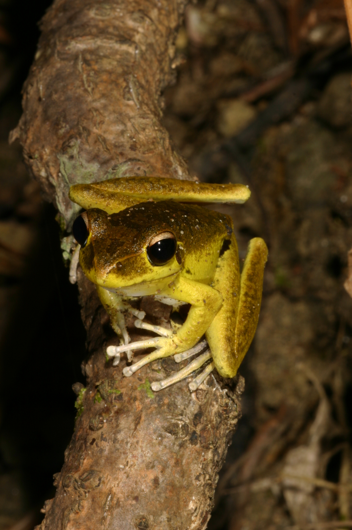
View all of the previous WetlandUpdates WetlandInfo feedback and improvementsSend us your useful wetland information and links to add to WetlandInfo. Do you have a wetland question you just can't answer? Email us Our WetlandInfo feature frog is a Litoria jungguy commonly known as the Northern Stony Creek Frog. Previously known as: Lesueur's Tree Frog or Rocky River Frog.
WetlandInfo updates this section regularly, so keep your eyes and ears open! For more information on frogs, visit Amphibiaweb or the Frogs of Australia website. Or view species profiles in your area using the SummaryInfo search tool. Last updated: 13 October 2014 This page should be cited as: Department of Environment, Science and Innovation, Queensland (2014) WetlandUpdate November 2014, WetlandInfo website, accessed 18 March 2024. Available at: https://wetlandinfo.des.qld.gov.au/wetlands/resources/publications/latest-news/2014-10-15.html |
Site footer

 — Department of Environment, Science and Innovation