

|
|
WetlandUpdate December 2018Catchment Stories: Lower Burdekin, Bohle and Southern Gold Coast CatchmentsTo effectively manage a catchment it is important to have a collective understanding of how the catchment works. Catchment stories use map journals, integrated spatial information, photographs, animations and an informative narrative to demonstrate the features of catchments. These stories describe the location, extent and values of the Lower Burdekin, Bohle and Southern Gold Coast Catchments. The stories demonstrate the key features which influence water flow, including geology, topography, rainfall and run-off, natural features, human modifications and land uses. The information was compiled using the walking the landscape process, where experts systematically worked through a catchment in a facilitated workshop, incorporating diverse knowledge of the landscape, to develop catchment stories. Moreton Bay - A wetland of International ImportanceAn updated factsheet has been developed providing information on the Moreton Bay Ramsar site. Additional linksShoalwater Corio Bays Ramsar Management SupportThe Fitzroy Basin Association has developed an interactive portal to increase awareness of the Shoalwater and Corio Bays Ramsar site's significance. The portal contains educational information to highlight condition and threats and is seen as a way of providing tools to improve collaborative efforts in site management. Great Barrier Reef Marine Park Authority Position Statement for Coastal EcosystemsThe Great Barrier Reef Marine Park Authority (the Authority) release Position statements to express the Authority's position on an issue where it has a strong interest, but outside it's direct regulatory control. These statements are based on the best available science and information. The Authority has released a position statement for Coastal Ecosystems. Burdekin cane growers save money and protect wetlands - videoNQ Dry Tropics have hosted a video on their YouTube channel about monitoring the quality and volume of water running off-farm. It can provide important data that can help growers make important business decisions. State of the Environment Report 2017The 2017 State of the Environment report is available on the Department of Science and Heritage website. The Queensland Government produces a State of Environment Report every 2 years. For the second year it has been published in a web-based format, providing an interactive experience for users to explore spatial data, text, tables, graphs and charts. Published through the Queensland Government Open Data Portal, the data is presented in themes: Biodiversity, Heritage, Pollution, Climate and Human Settlements and Great Barrier Reef. Biodiversity and Ecosystems Climate Adaptation PlanThe Biodiversity and Ecosystems Climate Adaptation Plan, a Sector Adaptation Plan, has been developed Under the Queensland Climate Adaptation Strategy and led by the National Climate Change Adaptation Research Facility (NCCARF).The report sets out the principles for responding to the biodiverstiy crisis being accelerated by climate change. Modelling gully erosion and riverine processesThis report has reviewed the current understanding of gully erosion and river sediment transport processes in Queensland Catchments, detailing how these processes have been represented in water quality models over the last 20 years. The aim of this publication is to use that understanding to describe conceptual models for these processes and suggest improvements that could be made to the model. Optimizing the management of riparian zones to improve the health of the Great Barrier ReefThe Tropical Water Quality Hub, part of the National Environmental Science Program (NESP), is evaluating past investments in riparian remediation to demonstrate effectiveness (Project 3.1.4), and enable improved targeting, of riparian remediation works for reducing streambank erosion to achieve improved water quality outcomes within the Great Barrier Reef. Default guideline values for water quality and sediment qualityDefault guideline values can provide a generic starting point for assessing water quality, including the assessment of sediment quality. The Water Quality Australia Website lists default guideline values for a limited number of sediment toxicities. The Global Wetland OutlookThe Ramsar Secretariat has released The Global Wetland Outlook webpage, which provides a current overview of global wetlands: their extent, trends, drivers of change and the responses needed to reverse the historical decline in wetland area and quality in an interactive website format. WetlandInfo has a new domain! Since the Machinery of Government changes in 2017, the previous Queensland Department of Environment and Heritage became the Queensland Department of Environment and Science. This change in structure and name has been reflected now in the domain name for WetlandInfo. Now is the time to update your bookmarks and links from https://wetlandinfo.ehp.qld.gov.au/wetlands/ to https://wetlandinfo.des.qld.gov.au/wetlands/ WetlandUpdateThe WetlandUpdate is a regular bulletin sent to subscribers to provide them with the latest WetlandInfo resources and tools, as well as case studies, video information and new project fact sheets. View all of the previous WetlandUpdates WetlandInfo feedback and improvementsContact us via email for feedback, information or questions about wetlands. WetlandInfo feature animal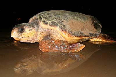
Caretta caretta
Col Limpus, QLD Government
Our December feature animal is the Loggerhead turtle or Caretta caretta.The loggerhead turle has a worldwide distribution and in Australia, occur in coral reefs, bays and estuaries in tropical and warm temperate waters off the coast of Queensland, Northern Territory, Western Australia and New South Wales.The Eastern Beach of South Stradbroke Island is a confirmed nesting location for these turtles.The loggerhead turtle (Caretta caretta) is endangered in Australia, meaning it may become extinct if the threats to survival continue. Loggerhead turtles are named after their relatively large-sized head. The average weight of an adult Loggerhead Turtle is 100-150 kilograms. The carapace grows to approximately one metre long and has five scales along each side. It is dark reddish brown in colour with darker brown markings. The plastron is creamy-yellow.
WetlandInfo updates this section regularly, so stay tuned for more! Last updated: 14 December 2018 This page should be cited as: Department of Environment, Science and Innovation, Queensland (2018) WetlandUpdate December 2018, WetlandInfo website, accessed 18 March 2024. Available at: https://wetlandinfo.des.qld.gov.au/wetlands/resources/publications/latest-news/2018-12-09.html |
Site footer

 — Department of Environment, Science and Innovation