

|
|
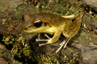
WetlandUpdate September 2013Groundwater dependent ecosystem (GDE) mappingThe GDE mapping has been extended to include the Mackay–Whitsunday and Pumicestone areas, and is supported by updated pictorial conceptual models and mapping rule sets. The Pumicestone mapping was funded by Healthy Waterways. The Queensland Wetlands Program funded the Mackay–Whitsunday mapping. The mapping was conducted by the Department of Science Information Technology Innovation and the Arts (DSITIA.) The GDE products were reviewed by regional experts and endorsed by the interdepartmental GDE mapping reference group. The wetland and GDE mapping and classification are available as KMLs (for use with Google Earth or similar program) through the WetlandSummary and WetlandMaps or via the Queensland Government Information Service. For further information on this mapping please refer to GDE background and FAQ. Wetland extent change statisticsWetland extent changes between pre-European and 2001, 2005 and 2009 have been determined for all areas (local government, regional NRM bodies etc.) and are delivered by the WetlandSummary tool. The wetland extent change information has never been available before at this scale. Previously data was only available on wetland extent changes at a broad level through the State of the Environment Report or the Reef Report Card. The historical figures may differ slightly from the reports above due to coastline differences and approaches to rounding off. They do however clearly show the same trends. Demonstration on how to use WetlandMapsAn animation has been developed to instruct users on how to use WetlandMaps. It provides information on the capabilities of the server and takes the user through the options and mapping layers they can activate to access new and detailed information. This animation was developed as a result of user feedback and with input from DSITIA and Department of Environment and Heritage Protection (EHP) staff. If you require mapping based information, take 10 minutes to explore what WetlandMaps. You’ll be amazed what it has to offer. Photo competitionWetlandCare Australia is launching its 7th annual Photography Prize inviting pictures exploring wetland themes: Wetland Flora, Wetland Fauna, Our Wetlands and Changing Landscapes. All categories are open to Australian residents of all ages. “Wetlands are one of the most valuable ecosystems on earth” said Prize Coordinator, Liz Hajenko. “I hope the competition will encourage people of all ages to get to know their local wetlands, and share their experiences and impressions of these important habitats,” she said. The winning photographs will be displayed on the WetlandCare Australia website and Facebook page, and at an exhibition in Townsville, Queensland, on World Wetlands Day (Febraury 2, 2014). WetlandUpdateWhen existing resources are updated or new tools are added to WetlandInfo, the WetlandUpdate newsletter is sent to subscribers with the changes featured on a What’s New summary page, now renamed WetlandUpdate. View all of the previous updates WetlandInfo feedback and improvementsSend us your useful wetland information and links to add to WetlandInfo. Do you have a wetland question you just can't answer? Email us Our WetlandInfo feature frog is a Litoria jungguy commonly known as the northern stony creek frog
WetlandInfo updates this section regularly, so keep your eyes and ears open! For more information on frogs and to hear their calls, visit the Frogs of Australia Or view species profiles in your area using the SummaryInfo search tool. Last updated: 22 March 2013 This page should be cited as: Department of Environment, Science and Innovation, Queensland (2013) WetlandUpdate September 2013, WetlandInfo website, accessed 18 March 2024. Available at: https://wetlandinfo.des.qld.gov.au/wetlands/resources/publications/latest-news/2013-08-08.html |
Site footer

 — Department of Environment, Science and Innovation