

|
|
WetlandUpdate July 2018Catchments of the Eastern Gulf of Carpentaria Aquatic Conservation Assessment projectAquatic Conservation Assessments (ACAs) are non-social and non-economic and designed with the sole intent of identifying conservation values of wetlands at a user-defined scale. In the Catchments of the Eastern Gulf of Carpentaria Aquatic Conservation Assessment the AquaBAMM methodology has been applied separately to the non-riverine (i.e. palustrine and lacustrine) and riverine wetlands within each of the Flinders, Norman, Gilbert, Staaten and Mitchell River catchments. View report: Aquatic Conservation Assessment using AQUABAMM for the riverine and non-riverine wetlands of Eastern Gulf of Carpentaria. The riverine and non-riverine assessments may be accessed through WetlandMaps. Find out more about accessing the data and reports on the get mapping help page. Environmental reports online provide information on specific environmental values, by location. Legislation PagesThe legislation toolbox has been reinstated after reflecting updates to Queensland planning legislation relating to wetlands, aquatic ecosystems and species. Check out the refreshed toolbox here on the Planning and Approvals pages. Calliungal Cattle Station Case StudySince the mid-19th century, landholders on Calliungal station have operated a beef cattle enterprise on the Calliungal floodplain, while negotiating the impacts of many floods, some devastating. This case study illustrates how Calliungal’s managers have tackled the challenges of floodplain grazing and applied recent technological innovations to achieve sustainable production—while retaining healthy wetlands and biodiversity. It provides information useful to landholders on land subject to major floods in Queensland. The case study can be found on the wetland projects search tool and reports pages. Terrain (Wet Tropics) Natural Resource Management GroupTerrain has developed catchment profiles incorporating Walking the Landscape processes. The Queensland Springs DatasetThe Queensland Herbarium has released a new dataset for springs in Queensland, providing point locations of active and inactive springs. The new data is available on WetlandMaps. The Queensland Springs Dataset is a key input into the Groundwater Dependant Ecosystem surface expression points data but does not replace it. Updates, improvements and linksAdditional linksThe Aquatic Ecosystems Toolkit Module 5: Integrated Ecosystem Condition Assessmentis now available on the Australian Government website. The Environmental Economic Accounting - Strategy and Action Plan sets out how a common national approach to the implementation of the United Nations System of Environmental-Economic Accounting will provide coherent and integrated data for decision making by governments, business and the community. More projects from Moreton Bay Regional Council and the Community Sustainability Action grants have also been added to the Wetland projects search tool. WetlandInfo has a new domain! Since the recent Machinery of Government changes in 2017, the previous Queensland Department of Environment and Heritage became the Queensland Department of Environment and Science. This change in structure and name has been reflected now in the domain name for WetlandInfo. Now is the time to update your bookmarks and links from https://wetlandinfo.ehp.qld.gov.au/ to https://wetlandinfo.des.qld.gov.au/ WetlandUpdateThe WetlandUpdate is a regular bulletin sent to subscribers to provide them with the latest WetlandInfo resources and tools, as well as case studies, video information and new project fact sheets. View all of the previous WetlandUpdates WetlandInfo feedback and improvementsContact us via email for feedback, information or questions about wetlands. WetlandInfo feature animalOur July feature animal is Ambassiss elongatus, also known as the elongate glassfish. Restricted to Gulf catchments, this perch like species is transparent to gray in colour. Despite it's restricted distribution, it is common in it's local habitat. It feeds mostly on aquatic and terrestrial insects and micro-crustaceans. Breeding in small ponds, it deposits it's eggs on aquatic vegetation. The elongate glassfish was one of the 41 priority taxa relevant to the riverine and non-riverine wetlands of the study areas in the Eastern Gulf of Carpentaria Aquatic Conservation Assessment. WetlandInfo updates this section regularly, so stay tuned for more! 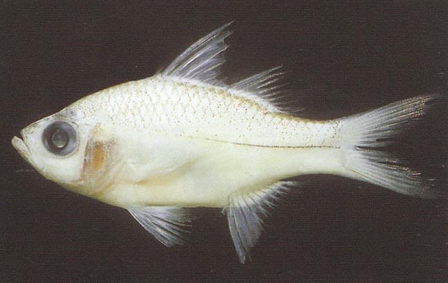
Elongate glassfish
Vanessa J. Thompson, Ambassis elongatus in Fishes of Australia, accessed 09 Jul 2018, http://fishesofaustralia.net.au/home/species/464
Last updated: 20 July 2018 This page should be cited as: Department of Environment, Science and Innovation, Queensland (2018) WetlandUpdate July 2018, WetlandInfo website, accessed 18 March 2024. Available at: https://wetlandinfo.des.qld.gov.au/wetlands/resources/publications/latest-news/2018-07-06.html |
Site footer

 — Department of Environment, Science and Innovation