

|
|
WetlandUpdate October 2023Wetlands Mapping Version 6.0
The Queensland wetland mapping and classification has been updated, based on 2019 wetland extent. Wetland mapping is used by State and local governments, Natural Resource Management (NRM) groups, consultants, and in research institutions to assist with prioritising management and conservation of wetlands and the various values that wetlands support. This update included critical review of the dataset, including redevelopment of some of the foundational background documentation. The release includes updates to the documentation, including:
 This release also includes:
Updated and new Ecology pages
Wetlands are dynamic systems that influence, and are influenced, by a complex range of environmental variables. The logic and structure of the Ecology section of the website has been significantly updated, to include more comprehensive information on ecosystem components (parts), processes, ecological cycles and spheres. This will assist with identifying, understanding, and quantifying the components and processes of wetlands, both of which are essential in understanding and quantifying the ecosystem services provided by wetlands. Knowledge of components and processes assists with developing management interventions and priorities that benefit and improve wetlands management, including priorities to on-ground projects. Quantifying the ecosystem services provided by wetlands aligns the management of wetlands to a Whole-of-System, Values-Based framework. Interim Queensland River Classification Scheme The Interim Queensland River Classification Scheme provides a standardised approach to describing and categorising the biological, physical and chemical characteristics (attributes) of rivers. The attribute-based classification scheme provides a common understanding and language of classification to improve communication and lead to better research, decision making and management outcomes. The approach underpinning the QRCS is consistent and integrated with the classification approach for all aquatic ecosystems in Queensland. The Queensland River Classification Scheme includes the release of:
Sandringham Lagoon Catchment Story A catchment story for Sandringham Lagoon has been added to the Plane Catchment Story. Developed with Reef Catchments NRM, the catchment story integrates spatial information, photographs, animations and an informative narrative to demonstrate the features of Sandringham Lagoon and it's surrounding catchment. Economic Valuation of ecosystem services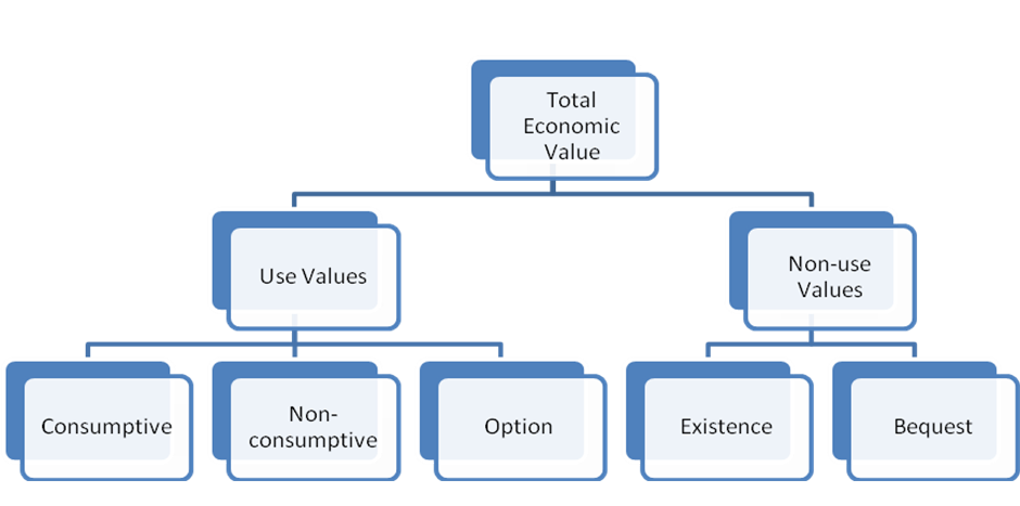 Information has been developed on the valuation of ecosystem services. Developed with the Department of Agriculture and Fisheries and reviewed by economic experts, this page provides a guideline for decision makers and policymakers in how to estimate the monetary value of ecosystem services. New Wetland Modelling PagesA new page has been developed to assist with understanding modelling. It includes information on what modelling is, types of modelling, modelling of processes and species, outputs of modelling and how modelling is used for wetland management. There is also a new page specifically for Wetland models. This guide will be important for wetland and catchment managers that will use modelling tools to assist with assessments and decision making. It also includes three new conceptual models to assist with understanding how wetlands are considered in hydrological modelling for nitrogen removal.  WetlandSummary updates and new Wetlands Insight Tool (WIT) chartsThe stacked line plots produced by the Digital Earth Australia (DEA) Wetlands Insight Tool (WIT) have been added to WetlandSummary. The stacked line plot charts display the amount of open water, wet, green vegetation, dry vegetation and bare soil over time. For WetlandSummary, the stacked line plot charts visually represent all the wetland areas in the area of interest, instead of one individual wetland (available via WetlandMaps). The stacked line plot charts have an interactive slider that helps to display the chart with the wetland size of interest. This allows the user to understand the open water within the identified wetlands of an area (termed fractional cover). The stacked line plot charts can be used to visualise droughts, major hydrological events, floods and how water in wetlands is changing over time.  Please note the stacked line plot charts are a data visualisation tool - any analysis of this data should be undertaken using the source data from GeoScience Australia. WetlandSummary now also includes:
Updates to Education ModulesWetland types and classification Education Module
Mapping wetlands in Queensland Education Module
The Ramsar Convention in Queensland Education Module
The Wetland types and classification and Mapping wetlands in Queensland education modules have been updated to reflect changes with Version 6 of the Wetlands Mapping. The The Ramsar Convention in Queensland has also been updated. New FactsheetsThe Whole-of-System, Values-Based Framework factsheet
Update of the Russell River Catchment Sustainability Plan Factsheet
Agriculture water treatment Project factsheet
UpdatesUpdated layers on WetlandSummaryPrograms, Policy and Legislation pagesReviewed and updated content to maintain accuracy and relevance. Additional links
WetlandUpdateThe WetlandUpdate is a regular bulletin sent to subscribers to provide you with the latest WetlandInfo resources and tools, as well as case studies, video information and new project fact sheets. WetlandInfo feedback and improvementsContact us via email for feedback, information or questions about wetlands. WetlandInfo feature species The feature species for October is Arbuscular Mycorrhizal Fungi. Arbuscular mycorrhizal fungi, (AMF), are a group of symbiotic microorganisms colonising vascular plant roots. Glomus is the largest genus of AMF, with 85 species described. AMF roots, and the associated networks of hyphae are a major component of most soils, but are usually not seen with the naked eye. AMF are thought to play key roles in detritus food webs (consumption of decaying organic matter) and nutrient cycling in mangrove ecosystems. The mycelium system of AMF can spread along plant roots and provide numerous areas for plant growth, and promotes rhizobacteria (root associated bacteria) to undertake phosphorus absorption. AMF colonisation among different mangrove species plays essential ecological functions in the nitrogen cycle, which is critical for various wetland plant growth and can aid in the maintenance of diverse plant communities. While there is still limited knowledge on these species, increasing evidence suggests that AMF could modify the nitrogen transformation and storage by coupling the diazotrophic community (nitrogen fixers) in the mangrove rhizosphere and hyphosphere (active zone of soil surrounding the mycelium) of the AMF[1]. Additional information
This section is updated regularly, so stay tuned for more! References
Last updated: 25 October 2023 This page should be cited as: Department of Environment, Science and Innovation, Queensland (2023) WetlandUpdate October 2023, WetlandInfo website, accessed 18 March 2024. Available at: https://wetlandinfo.des.qld.gov.au/wetlands/resources/publications/latest-news/2023-10-10.html |

Site footer

 — Department of Environment, Science and Innovation