

|
|
Wetland hydrological modelsWetland models enable users to quantify and predict the performance of wetland systems. This is important to understand how best to use both natural and constructed treatment wetlands to improve water quality, and to support wetland rehabilitation[2].
Quick fact
Wetland hydrological models – Wetland site scaleSelect from the tabs below
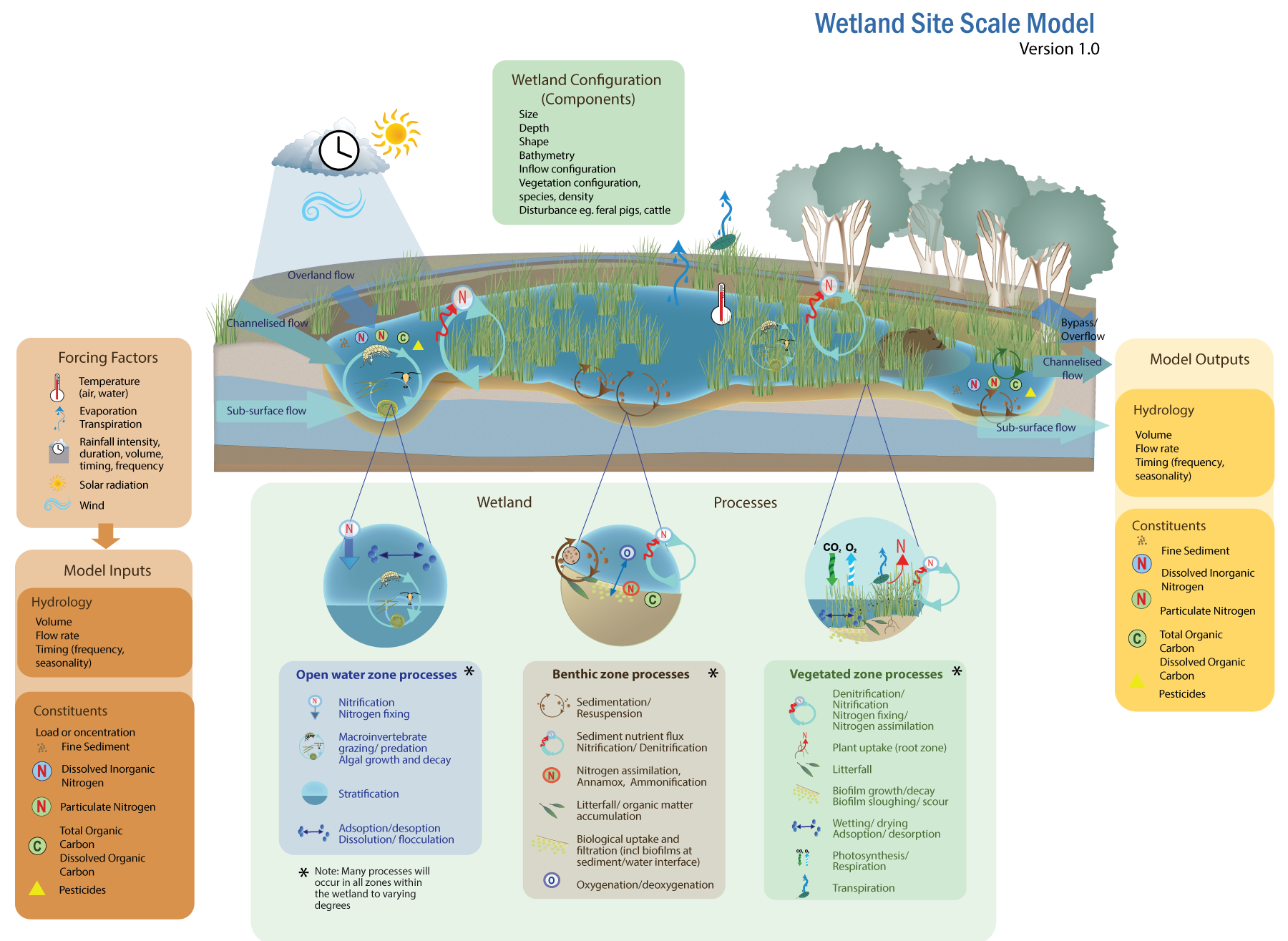 The conceptual model for the wetland site scale shows the factors influencing inputs to a wetland hydrologic model, the hydrological and nutrient processes within the wetland, the wetland components that influence water flows and processes, and the outputs from a wetland model. The conceptual model focusses mainly on nitrogen processes within a wetland but other processes and constituents can be incorporated into a model depending on the modelling purpose. Forcing factors – these are the factors (e.g. temperature, evaporation, rainfall intensity, duration, volume, timing and event frequency, solar radiation, wind) that influence the model inputs, including the amount and flow of water in the catchment or area of interest and the constituents (e.g. nutrients and pesticides) carried by the water. Landscape – these factors affect the forcing factors and contribute to the resultant runoff and constituent inputs. Wetland configuration (components) – these describe the physical components of the wetland itself, which in turn affect flow within the wetland (e.g. size, depth, shape, bathymetry, inflow configuration (controls and inlet type such as pipe, channel, rock weir)), vegetation configuration (species, shape, density). Model inputs – these are water inputs to the wetland which can be divided into: overland flow, channelised flow, and sub-surface flow. The flow rates, volume, and timing (frequency, seasonality) of the inflows will vary depending on the forcing factors and landscape parameters (see contributing catchment conceptual model). For a site scale wetland model the inputs may be generated from another model or dataset. Model inflow constituents – the concentrations of pollutants such as fine sediment, dissolved inorganic nitrogen (DIN), particulate N, carbon, pesticides or other contaminants. Wetland Processes – the nitrogen processes in wetlands vary depending on the environment:
Model outputs - these are water outputs from the wetland which can be divided into: bypass or overflow, channelised flow, and sub-surface flow. The flow rates, volume, and timing (frequency, seasonality) of the outflows will vary depending on the inputs, and water flow and storage within the wetland itself. References
Last updated: 31 May 2023 This page should be cited as: Department of Environment, Science and Innovation, Queensland (2023) Wetland hydrological models – Wetland site scale, WetlandInfo website, accessed 18 March 2024. Available at: https://wetlandinfo.des.qld.gov.au/wetlands/facts-maps/modelling/wetlands-modelling/wetland-site-scale.html |
Site footer

 — Department of Environment, Science and Innovation