|
|
Quick facts
- The State
-
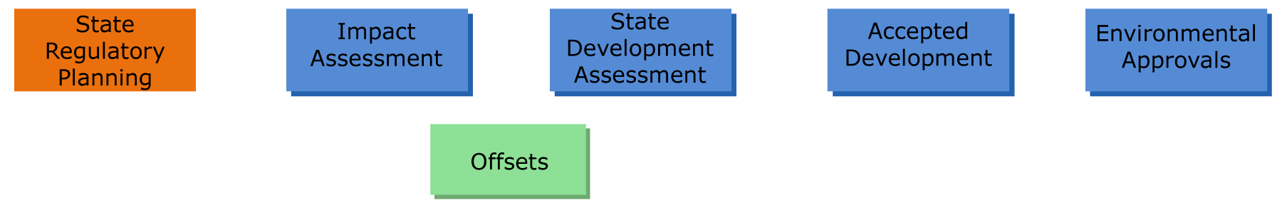
The State Planning Policy (SPP) sets out the state's interests in planning and development assessment in a single instrument for the whole of Queensland. The SPP protects ecosystems and their ecological processes, by ensuring that planning and development decisions maintain and enhance biodiversity. For example, the conservation of wetlands contributes to community wellbeing and economic development by protecting the ecosystem services that wetlands provide.
| Planning instruments |
|
The Planning Act 2016 (Planning Act) establishes the legal framework for land use planning and development assessment in Queensland. The State Planning Policy (SPP) outlines the State's interests for planning and development assessment.
To protect or give effect to the State’s interests, local government planning schemes need to integrate policies in the SPP (where relevant), to their local government area.
|
State interests for wetland biodiversity
Under the Planning Act 2016, local government planning schemes are required to integrate State interests for their local government area, as expressed in the State Planning Policy 2017 and regional plans.
The SPP expresses 17 State interests in planning and development which are grouped into five themes, one of those being the Environment and Heritage theme which includes biodiversity, coastal environment, cultural heritage and water quality. Protection of wetland values are mainly addressed through the Environment and Heritage theme.
The SPP is supported by mapping of most matters of state environmental significance (MSES) including high ecological value (HEV) aquatic ecosystems (watercourses and wetlands), wetlands in wetland protection areas (WPA) or wetlands of high ecological significance (HES). It also shows HEV waters for the purposes of achieving water quality policy outcomes. An SPP interactive central online mapping portal is available that spatially represents matters of State interest for local governments to use when making or amending their planning schemes.
The MSES mapping is linked to other regulatory mapping for wetlands including the Map of Great Barrier Reef WPAs and the Map of Queensland wetland environmental values.
The Map of Great Barrier Reef WPAs is a regulatory map under the Environmental Protection Regulation 2019. It identifies the location of WPAs in Great Barrier Reef (GBR) catchments. Development (high impact earthworks) in WPAs is assessed against State Development Assessment Provisions (SDAP) state code Great Barrier Reef Wetland Protection Areas. This map applies to prescribed activities under the Environmental Protection Regulation 2019 and other SDAP state codes that require offsets for MSES which are listed as prescribed environmental matter(s) (PEM) under the Environmental Offsets Regulation 2014 where impacts cannot be avoided, minimised or mitigated.
The Map of Queensland wetland environmental values is a state-wide regulatory map under the Environmental Protection (Water and Wetlands Biodiversity) Policy 2019. It identifies HES wetlands and wetlands of general ecological significance (GES) across the state. HES wetlands on the map are identified as a PEM under the Environmental Offsets Regulation 2014.
Regional plans are used to further address State interests identified in the SPP by focussing on issues that require a regionally specific policy direction. Regional plans can identify regional biodiversity values and corridors which can include wetlands and watercourses.
Beneath regional plans, sit the local government planning schemes. Planning schemes are used to plan and regulate for development in each local government area. The SPP State interest of Biodiversity requires that local governments identify and protect against any potential, significant adverse environmental impacts on matters of environmental significance, at the national, state and local scale. Planning schemes can reflect State interests in biodiversity through planning policies and development assessment benchmarks that ensure development is located to avoid, or mitigate impacts to matters of environmental significance and maintain or enhance biodiversity resilience to support ecological integrity.
|
Resources
|
| Scheduled EVs/WQOs & Healthy Waters Management Plan |
|
The aim of the Environmental Protection Act 1994 (EP Act) is to protect Queensland's environment while allowing for development that improves the total quality of life, both now and in the future, in a way that maintains the ecological processes on which life depends. This approach is termed 'ecologically sustainable development'.
The Environmental Protection (Water and Wetland Biodiversity) Policy 2019 (Water and Wetlands EPP), under the EP Act, establishes environmental values (EVs) and water quality objectives (WQOs) including Great Barrier Reef River Basins End of Basin Load Water Quality Objectives (Reef WQOs) to protect Queensland's waters, and wetlands and Great Barrier Reef while supporting ecologically sustainable development. Queensland waters include water in rivers, streams, wetlands, lakes, groundwater aquifers, estuaries and coastal areas.
To protect or give effect to the State’s interests for water quality, environmental values are addressed in Healthy Waters Management Plans (HWMPs).
|
Mechanism and recognition of wetland values
The Environmental Protection (Water and Wetland Biodiversity) Policy 2019 (Water and Wetlands EPP) establishes a framework for identifying environmental values (EVs) for waters and wetlands, and water quality objectives (WQOs) including Great Barrier Reef River Basins End of Basin Load Water Quality Objectives (Reef WQOs) for receiving waters. EVs are the qualities that make water and wetlands suitable for supporting aquatic ecosystems and human use. WQOs apply to receiving waters including freshwater, estuarine and marine wetlands. The Reef WQOs establish annual loads for sediments and dissolved inorganic nitrogen to meet the end-of-catchment targets set out under the Reef 2050 Water Quality Improvement Plan, which are to be considered when assessing new and expanding development within the Great Barrier Reef catchments.
For water EVs, the Water and Wetlands EPP identifies four levels of protection according to the current condition of the waters, these are 1) high ecological value, 2) slightly disturbed, 3) moderately disturbed and 4) highly disturbed. The Water and Wetlands EPP states how each level should be protected. WQOs and EVs have been developed for particular catchments and are listed in the Water and Wetlands EPP, Schedule 1. In areas where this has not been completed, there are guidelines for WQOs for all indicators aimed at protecting all EVs. The Water and Wetlands EPP also provides for the development of HWMPs.
|
Resources
|
| Water Plans |
|
The Water Act 2000 provides a legislative basis for the sustainable planning and management of the State’s water resources. The Water Act outlines the State’s interests for water resources.
To protect or give effect to the State’s interests, matters relating to water resources are addressed in Water Plans.
|
Mechanism and recognition of wetland values
Water Plans (previously called Water Resource Plans) provide the management framework for water resources, outlining outcomes, objectives and strategies for achieving a sustainable balance between water users and the environment.
The framework ensures that water allocation optimises the balance between economic, environmental, social and cultural outcomes. The water plan states environmental outcomes associated with the allocation and use of water in the plan area. These outcomes include consideration of wetlands and watercourses and, if necessary, underground water and overland flow.
The water plans also state arrangements for providing water for the environment including the measures, strategies or objectives for environmental flows. Technical and scientific assessments as well as community consultation are critical inputs to the planning process. A water plan may also specify criteria for deciding an application about taking water. This may include for example, whether granting the application is likely to adversely affect natural aquatic ecosystems, including wetlands. Matters relating to works for taking or interfering with water are dealt with under the Planning Act 2016. They are prescribed under the Planning Regulation 2017 and development applications are assessed against the State Development Assessment Provisions (SDAP). An SDAP state code establishes outcomes for works to support the sustainable management of the taking of water.
|
Resources
|
| Coastal Planning |
|
The Coastal Protection and Management Act 1995 (Coastal Act) provides for the protection and management of coastal resources and biodiversity, including coastal wetlands, and ensures decisions about land use development safeguard life and property from the threat of coastal hazards. It achieves this by defining coastal management districts and erosion-prone areas where coastal planning and development assessment provisions apply under the Planning Act. The Coastal Act outlines the State’s interests for coastal protection and management in the coastal zone.
To protect or give effect to the State’s interests, matters relating to development in the coastal zones are addressed in the State’s Coastal Management Plan.
|
Mechanism and recognition of coastal wetland biodiversity
The Coastal Act defines the coastal zone and coordinates and integrates planning and decision making within it. The objects of the Coastal Act are achieved through the implementation of the Coastal Management Plan which includes policies that can protect wetlands through maintaining coastal landforms and physical coastal processes and conserving nature. The Coastal Act also sets out coastal management districts where special development controls and management practices are in place, some of which contribute to the protection of coastal resources such as wetlands and the services they provide.
Matters relating to coastal development are dealt with under the Planning Act 2016. They are prescribed in the Planning Regulation 2017 and development applications are assessed against the SDAP. SDAP state code Coastal development and tidal works establishes outcomes for works to support the sustainable management of coastal resources.
|
Resources
Coastal management
Coastal development
|
| Declared Fish Habitat Area Plans |
|
The Fisheries Act 1994 (Fisheries Act) provides for the use, conservation and enhancement of the community's fisheries resources and fish habitats. The Fisheries Act outlines the State’s interests in relation to declared fish habitat areas (FHA). The Fisheries (General) Regulation 2019 (Schedule 3) provides details on the area included within the declared FHA boundary.
To protect or give effect to the State’s interests, matters relating to declared FHAs are addressed through declared FHA plans.
|
Mechanism and recognition of coastal wetland biodiversity
Queensland's declared FHA network provides long-term protection for fish habitats that are essential to sustaining our fisheries.
Declared FHAs are protected from physical disturbance associated with coastal development under Queensland's Fisheries Act 1994.
There are many declared FHAs along the Queensland coast that protect more than 1.2 million hectares of high-quality fish habitats.
Gazetted plans showing the locations of declared FHAs in Queensland are available online and Geographic Information System (GIS) coverage of the declared FHA network is available from the Queensland Spatial Catalogue by searching for ‘fish habitat areas’.
|
Resources
Declared fish habitat area plans
Declared fish habitat areas: Frequently asked questions
|
| Pest Management Plans |
|
The Biosecurity Act 2014 (Biosecurity Act) and Biosecurity Regulation 2016 provide a comprehensive, consistent and risk-based approach to the management of biosecurity risks to safeguard our economy, agricultural and tourism industries, environment and way of life, from:
- pests (e.g., wild dogs and weeds)
- diseases (e.g., Hendra virus)
- contaminants
The Biosecurity Act outlines the State’s interests for biosecurity. To protect or give effect to the State’s interests, matters relating to biosecurity are addressed through local government biosecurity plans.
|
Mechanism and recognition of wetland values
Pest animals, plants and diseases are major threats to biodiversity and wetland values. The management of biosecurity risks occurs at all levels - national, state, regional, local and property. For example, the Biosecurity Act imposes a ‘general biosecurity obligation’ (GBO) on all Queenslanders. The GBO means that everyone is responsible for managing biosecurity risks that are under their control and that they know about or should reasonably be expected to know about. The Biosecurity Act also requires every local government in Queensland to develop a biosecurity plan for their area. These biosecurity plans bring together all sectors of the local community to manage invasive plants and animals, and ensure resources are targeted at the highest priority and most effective pest management activities. A local government area biosecurity plan should identify declared pest species in the area and prioritise management actions, such as the removal of invasive species to improve environmental values such as wildlife habitat.
|
Resources
|
| Protected Area Plans |
|
The object of the Nature Conservation Act 1992 (NC Act) is to conserve nature while allowing for the involvement of Indigenous people in the management of protected areas in which they have an interest under Aboriginal tradition or Island custom. The object is to be achieved through an integrated and comprehensive conservation strategy for the whole of the State that involves among other things, the dedication/declaration and management of protected areas and the protection of native wildlife and its habitat. The NC Act outlines the State’s interests for protected area management.
To protect or give effect to the State’s interests, matters relating to protected area management are addressed through protected area management planning.
|
Mechanism and recognition of wetland values
A management plan or a management statement for a national park and other types of protected areas on public land sets out the values to be protected and information on managing those values consistent with management principles under the NC Act. A management statement is a simple expression of management intent for an area. Management plans include strategies, actions and guidelines for achieving stated outcomes such as maintaining or enhancing wetland values. For example, the removal of pest species, maintaining water quality and managing recreational uses in the area. Protected areas on private land (i.e., nature refuges) are managed according to the terms and conditions of a binding perpetual conservation agreement negotiated between the landholder and the state under the NC Act. Because nature refuges are a class of protected area under the NC Act, the protected area provisions under the NC Act also apply. The conservation agreement details the significant conservation values to be protected on the land and provides a framework for sustainably managing the nature refuge.
|
Resources
|
| State Marine Park Zoning Plans |
|
The aim of the Marine Parks Act 2004 (MP Act) is to provide for conservation of the marine environment through the declaration and management of marine parks. Zoning plans state the entry and use provisions for each State marine park. The MP Act outlines the State’s interests for marine parks.
To protect or give effect to the State’s interests, matters relating to activities within a marine park are addressed in marine park zoning plans.
|
Mechanism and recognition of wetland values
There are three State marine parks established under the MP Act —Moreton Bay Marine Park, Great Sandy Marine Park and the Great Barrier Reef Coast Marine Park. Each multi-use marine park is established to protect and manage the unique natural features within the park. The Marine Parks Regulation 2017 describes the zones allowed and sets objects for each zone. Each marine park has a zoning plan that identifies and maps the zones. The activities that are allowed in each zone depends on the object for that zone. The zoning plan also specifies whether a permit is required to enter or use the zone for an activity. The Great Barrier Reef World Heritage Area includes the Commonwealth Great Barrier Reef Marine Park and the State Great Barrier Reef Coast Marine Park. In this area, zoning is complementary, with matching requirements for both the State and Commonwealth marine parks.
|
Resources
- Information and links to State zoning plans and designated areas.
- Information on permits for (State only) Marine Parks.
|
| Species Recovery Plan/Conservation Plans |
|
The object of the Nature Conservation Act 1992 (NC Act) is to conserve nature while allowing for the involvement of indigenous people in the management of protected areas in which they have an interest under Aboriginal tradition or Island custom. The object is to be achieved through an integrated and comprehensive conservation strategy for the whole of the State that involves among other things, the dedication/declaration and management of protected areas and the protection of native wildlife and its habitat. The NC Act outlines the State’s interests for threatened species.
The Environment Protection and Biodiversity Conservation Act 1999 (EPBC Act) is the Australian Government’s central piece of environmental legislation. It provides a legal framework to protect and manage nationally and internationally important flora, fauna, ecological communities and heritage places—defined in the EPBC Act as matters of national environmental significance (MNES).
To protect or give effect to the State’s interests in relation to threatened species including the Commonwealth’s MNES, matters may be addressed through species recovery and conservation plans.
|
Mechanism and recognition of wetland values
At a State level, species listed as threatened (critically endangered, endangered, vulnerable) and near threatened under the Nature Conservation (Plants) Regulation 2020 and the Nature Conservation (Animals) Regulation 2020 may have conservation plans prepared for them. At a national level, species listed as threatened (critically endangered, endangered and vulnerable) under the EPBC Act may have threatened species recovery plans prepared for them.
Recovery plans have been developed under the EPBC Act. Each plan states the research and management actions necessary to stop the decline, support the recovery and enhance the chance of long-term survival in the wild of a protected species or community. Recovery plans include actions for identifying, protecting and managing species habitat including wetlands.
Conservation plans prepared under the NC Act allow for the ecologically sustainable take and use of protected wildlife from the wild for commercial and non-commercial purposes.
|
Resources
|
Disclaimer
While every care is taken to ensure the accuracy of this product, the Queensland Government and Australian Government make no representations or warranties about accuracy, reliability, completeness or suitability for any particular purpose and disclaim all responsibility and all liability (including without limitation, liability in negligence) for all expenses, losses, damages (including indirect or consequential damage) and costs which might be incurred as a consequence of reliance on the product, or as a result of the product being inaccurate or incomplete in any way and for any reason.
Last updated: 11 July 2023
This page should be cited as:
Department of Environment, Science and Innovation, Queensland (2023) State regulatory planning, WetlandInfo website, accessed 18 March 2024. Available at: https://wetlandinfo.des.qld.gov.au/wetlands/management/legislation-update/state-reg-planning/
|


 — Department of Environment, Science and Innovation