Skip links and keyboard navigation

Queensland Murray-Darling Freshwater Biogeographic Province

Queensland Murray-Darling Freshwater Biogeographic Province

Wet season (Jan-May) Average temperature (20°) Temperature varies along a west east gradient Evaporation exceeds rainfall Width of riparian zone (29m) Medium trees Grasses Low relief ratio Cracking clays Percentage of water which is base flow (9%) Annual spate duration (1 month) Annual no-flow duration (5 months) Clay Low macroinvertebrate richness High turbidity Large woody debris cover (8%) Submerged and emergent macrophyte growth forms dominant Concave bank shape category Convex bank shape category Dominant bank slope (10°-80°) Fauna Specific example – Life cycle of Golden Perch

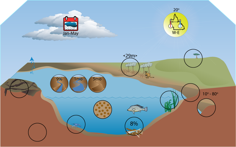
Click on elements of the model or select from the tabs below

The Queensland Murray-Darling Freshwater Biogeographic Province (FBP) consists of the Border Rivers, Moonie, Balonne-Condamine, Warrego and Paroo drainage basins, and is located in the south-west of the State. The headwaters of these basins rise in the Great Dividing Range and the rivers flow across the Queensland-New South Wales border to eventually form one of the largest catchments in the world[1]. The rivers within the FBP are flat over much of their courses and floodplains are extensive. Prolonged periods of low or no flow are typical as are unpredictable high flow events that inundate the floodplains ephemeral lakes and wetlands. Much of the FBP can be considered arid or semi-arid, experiencing infrequent rainfall. The FBP incorporates the Brigalow Belt, New England Tableland, Mulga Lands, and Mitchell Grass Downs vegetation bioregions. Many fauna and flora species found in the Queensland Murray-Darling FBP do not occur elsewhere in Queensland.

Key ecological implications—Murray-Darling FBP
C G&T HY WQ H
Many species have either flexible/opportunistic life histories or long life spans
Species may utilise annual cues for critical life history activities (e.g. Murray Cod and turtle)
Species utilise drought refugia (especially waterholes) and/or have traits for surviving drought, or rapidly recolonising afterwards
Low diversity of aquatic macroinvertebrates due to fine substrates and low light penetration
Large woody debris performs the same habitat function as large rocks would in other FBPs
Primary productivity limited to phytoplankton near water surface and shallow littoral benthic algal production
Food webs largely driven by littoral benthic production
Over long time scales most aquatic primary productivity occurs on the floodplain when inundated
Cold minimum temperatures limit productivity rates and may exclude some species
Diversity of temperatures may lead to high biodiversity

References

  1. ^ Young, WJ (2001), Rivers as Ecological Systems: The Murray-Darling Basin, CSIRO Land and Water, Murray-Darling Basin Commission, Canberra.

Last updated: 22 March 2013

This page should be cited as:

Department of Environment, Science and Innovation, Queensland (2013) Queensland Murray-Darling Freshwater Biogeographic Province, WetlandInfo website, accessed 18 March 2024. Available at: https://wetlandinfo.des.qld.gov.au/wetlands/ecology/aquatic-ecosystems-natural/riverine/freshwater-biogeo/murray-darling/

Queensland Government
WetlandInfo   —   Department of Environment, Science and Innovation