

|
|
Queensland Murray-Darling Freshwater Biogeographic ProvinceQueensland Murray-Darling Freshwater Biogeographic Province – Geology and topography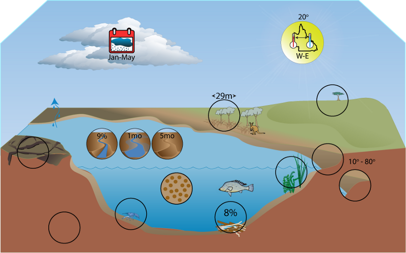 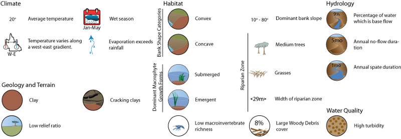 Click on elements of the model or select from the tabs below
GeologyThe main surface soil type in the Murray-Darling FBP is cracking, heavy, grey to grey-brown clay, the most common type in the northern Murray-Darling Basin being montmorillonite[3]. The composition of clay results in it cracking in dry conditions, and expanding during wet periods. Cracking allows water and organic matter to enter the soil[3]. Coarser alluvial material underlies these surface soils, and deeper alluvial deposits form the sedimentary aquifers of the Great Artesian Basin that covers much of the FBP. Smaller areas of surficial aquifers and fractured rock aquifers exist in the upper reaches in the eastern part of the FBP[1]. Clay is composed of small particles less than 2 mm in size. These particles are easily suspended in water, and contribute to high turbidity. High turbidity has always been a natural feature of the river water in the Murray-Darling Basin[1]. The presence of clay soils limit the vegetation communities that can occur in the Murray-Darling FBP. Many plant species that are adapted to well-drained soils cannot survive on clay soils, and vice versa. Clay expands when wet and causes surface water to pond. The consequences of prolonged anoxia in the root zone are often detrimental to vegetation. Some species that occur on clay soils have evolved adaptations to temporary waterlogging. River red gum (Eucalyptus camaldulensis) seedlings, for example, develop adventitious roots, and have a honeycomb-like tissue with large intercellular spaces present that assists aeration during waterlogged periods[2]. High turbidity, resulting from the suspension of clay particles, reduces the amount if light that can penetrate the water. Reduced light availability influences the species and abundances of algae and macrophytes that can be encountered.
Terrain
Most of the Murray-Darling FBP has a low relief ratio, with a mean for the FBP of 0.013. High relief ratio values are confined to the upper catchment areas within the FBP, particularly around the foothills of the Great Dividing Range to the east and north. Stream segment slope values throughout the FBP are also on average low, with higher values corresponding to areas with high relief ratio values. The FBP has a reasonably even distribution of flatness index classes. Only a small proportion of the FBP contains ridge top flat areas, with most of the FBP falling into either valley bottom flat or erosional classes. Erosional flatness classes are characteristic of the upper catchments in the FBP, whereas depositional valley bottom flat areas are confined to the lower portions of catchments. The generally shallow relief and low stream slopes contributes to low disturbance intensity of spates in the FBP. The even distribution of flatness index classes implies a high diversity of aquatic habitat types, ecosystem types and aquatic assemblages at the FBP scale. However the shallow relief, even in most erosional areas, may act to limit this diversity, as is implied by the relatively limited prevalence of coarse substrate types in the FBP. The streambed substrate in depositional areas (valley bottom flat), is usually silt/clay. Species that have morphological, physiological and behavioural traits to suit coarser bed material such as cobbles, (for example macroinvertebrates from the family Psephenidae), cannot survive in silt/clay environments. Such species are likely to be restricted to the erosional parts of the FBP. Depositional areas are also associated with high turbidity. The widespread occurrence of valley bottom flat areas suggests floodplains and the processes associated with floodplain inundation are likely to be important to the ecology of Murray-Darling rivers. For instance many fish species have much better recruitment success when juveniles are able to access inundated floodplains where food resources (driven by heightened rates and areas of production) can be much more plentiful than when water is confined to the channel.
References
Last updated: 22 March 2013 This page should be cited as: Department of Environment, Science and Innovation, Queensland (2013) Queensland Murray-Darling Freshwater Biogeographic Province – Geology and topography, WetlandInfo website, accessed 18 March 2024. Available at: https://wetlandinfo.des.qld.gov.au/wetlands/ecology/aquatic-ecosystems-natural/riverine/freshwater-biogeo/murray-darling/geology-topography.html |
Site footer

 — Department of Environment, Science and Innovation