Skip links and keyboard navigation

Terrain pattern

Terrain pattern consists of the spatial patterns formed by surface terrain morphologies of the earth’s terrestrial, freshwater, and intertidal areas, and the sea floor. Examples include a network of channels and banks that make up a delta. To describe such terrain patterns, a map of terrain morphological units at the scales below the level at which the pattern is being described, is required.

Terrain pattern describes the spatial organisation of terrain morphological features (morphs) and their combinations at different scales. These terrain morphological features (morphs) form patterns across the landscape / seascape in a recognisable sequence of combinations which can be applied at hierarchical scales.

Terrain pattern: binary - channels and planes. Image by Queensland Government

Quick facts

Human structures and activities
change terrain pattern, altering the way geomorphological, hydrological and ecological processes interact with the landscape and seascape.

Terrain pattern is a combination of basic units that are either elevated, depressed or planar (flat)[4] and consists of the spatial arrangement of the physical shapes of the group of terrain morphological features. The patterns are a result or end point of the processes (e.g. geomorphological, soil-forming, coastal, hydrological processes), that have given rise to them.

Wetland terrain patterns and other wetland characteristics can be used to delineate, map and type wetlands, to gauge wetland health, and to inform aquatic ecosystem rehabilitation. People value the terrain patterns of wetlands and appreciate their aesthetic beauty, intrinsic and existence value (e.g. K’gari’s patterned fens and lakes, reefs and geomorphic patterns of the Great Barrier Reef)[17].

Patterns of spatial organisation in the landscape and seascape due to geomorphological, hydrological, soil-forming and ecological processes explain how and why these patterns appear as they do. Geomorphology seeks to understand how earth’s processes (e.g. air, water, ice) have influenced landforms and sediments. Landscape ecology aims to understand relationships between spatial patterns and ecological processes[19]. While it is not possible to map their genesis or origin, terrain patterns themselves are mappable where processes have created repeatable and interrelated shapes and forms[9]. Terrain pattern depends on already having a mapped attribute of terrain morphology as the basic building blocks of the terrain, to establish what combinations of patterns exist.

Elevation data captured digitally in digital elevation models (DEMs), digital terrain models (DTMs) and bathymetry forms an important information source from which to extract terrain pattern. Terrain pattern is scale-dependent, (i.e., a ridge at one scale may part of a plane at another scale) and it is very important to specify at which scale the terrain pattern is being applied. A digital terrain model can be used to derive metrics of terrain relief, roughness and slope. Thresholds for categories will be defined based on the index used, usually derived from a digital bathymetric model or digital elevation model, with consideration of scale and purpose of the classification.

The easiest way to understand terrain pattern is to go from the simplest patterns in the terrain (terrain morphology) to the most complex.

Binary combinations - examples

Binary combinations, photo by Queensland Government

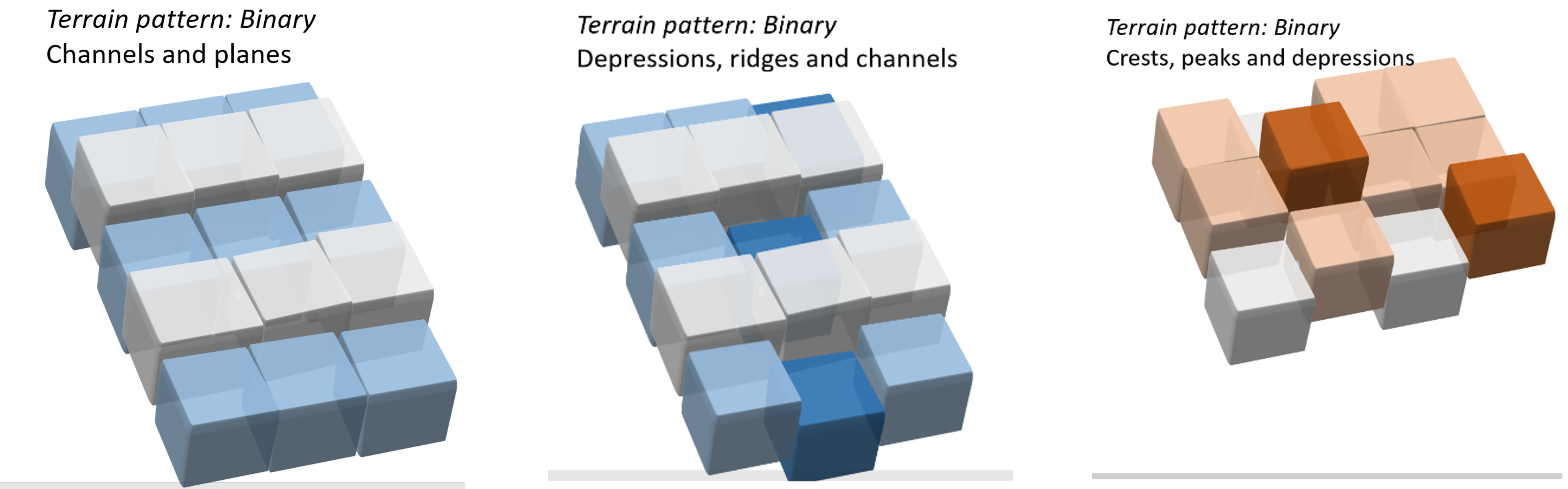
Ternary combinations and cross-scale patterns

Ternary combinations and cross scale patterns, photo by Queensland Government

Terrain pattern can be combined with other mapped terrain attributes (e.g. terrain slope, terrain relative relief, terrain roughness, benthic depth) to devise typologies for specific purposes, such as to describe compound topographic forms or geomorphic types (for example coral reef ‘geomorphic zones’, coral reef morphological regions, estuary types, river types). Additional spatial attributes may be required[8], such as:

  • proximity rules that apply to specific attributes, e.g. ‘a (reef) crest is always next to a (reef) flat’[13].
  • channel average spacing (dependent on the scale of the typology)
  • channel dimension (depth relative to width)
  • channel patterns such as distribution, integration, directionality etc.

Approaches to developing Terrain Pattern

There are several different approaches to characterising terrain patterns, depending on the system concerned and the purpose of the classification. The simplest approach is by zooming out on a three-dimensional map, from the landscape/seascape scale to the subregional scale. Soils-oriented classifications of terrain patterns focus on soil-forming processes such as runoff and drainage through the soil, interacting with landform patterns due to geology. Riverine classifications of terrain patterns focus on channel networks, shape of the riverbank and floodplain and dimensions and interactions with surrounding areas such as floodplains.

The terrain pattern definition and ways of measuring it is based on “landform pattern” as defined by the National Committee on Soil and Terrain (2009)[15], a geomorphological typology interpretation of the terrain, based on the patterns formed. Terrain pattern is distinguished from landform pattern by describing what the shape and spatial pattern combinations are rather than the how they formed. In addition to terrain pattern and geomorphological origin, landform pattern types also consider relief and modal slope.

The concept of scale as defined by landform pattern aligns with terrain pattern. In soil and land surveying landforms are described in terms of landform pattern ‘tiles’ (>600m across, 1:200,000 – analogous to the scheme’s subregional level), which in turn are composed of smaller landform element ‘tiles’ (about 40m across, 1:15,000 – analogous to the scheme’s seascape to habitat levels) and even smaller ‘site’ tiles (10m radius, analogous to community level)[15].

Terrain pattern and wetlands function

The patterns of surface terrain morphology are recognised as being important controls for wetlands at a variety of scales. Elevation and its patterns interact with weather systems and rainfall. Patterns of terrain influence the hydrology of catchments on the land, including slope, aspect, topographic shading, affect soil runoff, drainage and permeability[18]. For this reason, digital terrain models are key feature of hydrodynamic models.

  • Surface terrain patterns influence soil-forming features, notably hydrosols are poorly-drained soils characteristic of wetlands that sit low in the landscape. Proximity between wetlands and their terrain pattern characteristics (e.g. distribution of channel networks, floodplain terrain pattern characteristics and waterholes) influence the basic hydrology of wetlands.
  • In the intertidal area, tidal wetlands form networks of channels that are subject to, and influence, the dispersal of tidal inundation along a channel and onto the intertidal area. Geomorphological features of coastal wetlands and dune systems, beaches and rocky headlands, estuaries[16][11] and coral reefs are underpinned by terrain patterns and their spatial attributes.
  • Terrain patterns of the sea floor and intertidal area in turn influence how hydrodynamic energy is circulated by tides, currents and waves[3][2][1]. Such hydrodynamic processes influence sediment transport and deposition in a feedback loop that in turn influences terrain pattern, ecosystem characteristics and the biodiversity associated with marine ecosystems[10]. Notably sea floor terrain is an important determinant of nursery features of mangrove and seagrass habitats[7], and drives the productivity and biodiversity of the sea floor via upwellings and currents (e.g. undersea canyons)[12].

Human structures and activities change terrain pattern, altering the way geomorphological, hydrological and ecological processes interact with the landscape and seascape. These changes have consequences for wetland components and processes. Identifying which terrain features and patterns are the result of human-induced changes can help with designing and implementing initiatives to rehabilitate wetland components and processes and the values and services dependent on this. For intertidal and subtidal ecosystems adding human structures through armouring of shorelines, reclamation of tidal wetland channels and sandbanks, straightening and concreting of tidal channels and formation of canal estates, ports etc. alters the terrain pattern (and associated geomorphological, hydrological and ecosystem processes)[6][5].

Role in wetland management

A fundamental understanding of the natural terrain pattern of wetlands and how human modification has changed wetland patterns and processes is important for wetland management. Terrain pattern is indicative of how a whole system is functioning at hierarchical scales, so it is an important consideration in the Whole-of-System, Values-Based approach to management. Importantly, terrain pattern shapes how water is moving through the landscape / seascape at multiple scales, reflects wetland processes and can be used for wetland delineation. Recognition of artificial terrain patterns is important for understanding where humans have altered wetland processes, and how / where these processes may be rehabilitated. The following examples identifies some areas where terrain patters are considered in management:

  • The ‘Walking the Landscape’ approach takes a catchment-based approach to understanding water movement through catchments to and through wetlands, considering terrain pattern in different parts of the catchment and how water is flowing through the wetlands.
  • Hydrodynamic process models consider catchment and wetland terrain pattern characteristics as key inputs to understanding the movement of water, materials and biota in, between and out of wetlands and the wider landscape.
  • Coastal process models for estuaries are underpinned by basic terrain pattern[16]features (e.g. sandbank orientation, enclosure).
  • Topography can be used to develop more physically realistic hydrologic and water quality models that directly account for the impact of topography on the hydrology[14].

References

  1. ^ Andutta, FP, Ridd, PV & Wolanski, E (2011), 'Dynamics of hypersaline coastal waters in the Great Barrier Reef', Estuarine, Coastal and Shelf Science, vol. 94, no. 4, pp. 299-305, Elsevier.
  2. ^ Andutta, FP, Kingsford, MJ & Wolanski, E (2012), '‘Sticky water’enables the retention of larvae in a reef mosaic', Estuarine, Coastal and Shelf Science, vol. 101, pp. 54-63, Elsevier.
  3. ^ Andutta, FP, Ridd, PV & Wolanski, E (2013), 'The age and the flushing time of the Great Barrier Reef waters', Continental Shelf Research, vol. 53, pp. 11-19, Elsevier.
  4. ^ Bolongaro-Crevenna, A, Torres-Rodríguez, V, Sorani, V, Frame, D & Arturo Ortiz, M (2005), 'Geomorphometric analysis for characterizing landforms in Morelos State, Mexico', Geomorphology, vol. 67, no. 3, pp. 407-422, Elsevier.
  5. ^ Borland, HP, Gilby, BL, Henderson, CJ, Connolly, RM, Gorissen, B, Ortodossi, NL, Rummell, AJ, Pittman, SJ, Sheaves, M & Olds, AD (May 2022), 'Dredging fundamentally reshapes the ecological significance of 3D terrain features for fish in estuarine seascapes', Landscape Ecology. [online], vol. 37, no. 5, pp. 1385-1400. Available at: https://link.springer.com/10.1007/s10980-021-01394-5 [Accessed 19 September 2023].
  6. ^ Borland, HP, Gilby, BL, Henderson, CJ, Connolly, RM, Gorissen, B, Ortodossi, NL, Rummell, AJ, Pittman, SJ, Sheaves, M & Olds, AD (July 2022), 'Dredging transforms the seafloor and enhances functional diversity in urban seascapes', Science of The Total Environment. [online], vol. 831, p. 154811. Available at: https://linkinghub.elsevier.com/retrieve/pii/S0048969722019040 [Accessed 19 September 2023].
  7. ^ Borland, HP, Gilby, BL, Henderson, CJ, Connolly, RM, Gorissen, B, Ortodossi, NL, Rummell, AJ, Nagelkerken, I, Pittman, SJ, Sheaves, M & Olds, AD (March 2023), 'Seafloor Terrain Shapes the Three-dimensional Nursery Value of Mangrove and Seagrass Habitats', Ecosystems. [online], vol. 26, no. 2, pp. 442-456. Available at: https://link.springer.com/10.1007/s10021-022-00767-4 [Accessed 19 September 2023].
  8. ^ Department of Environment and Heritage Protection (2017), Queensland Intertidal and Subtidal ecosystem classification scheme Version 1.0: Module 1—Introduction and implementation of intertidal and subtidal ecosystem classification. [online], Queensland Wetlands Program. Available at: https://wetlandinfo.des.qld.gov.au/resources/static/pdf/resources/reports/intertidal-subtidal/module-1-int-sub.pdf.
  9. ^ Dove, D, Nanson, R, Bjarnadóttir, LR, Guinan, J, Gafeira, J, Post, A, Dolan, MFJ, Stewart, H, Arosio, R & Scott, G (7 October 2020), A two-part seabed geomorphology classification scheme (v.2); Part 1: morphology features glossary. [online], Zenodo. Available at: https://zenodo.org/record/4075248 [Accessed 19 September 2023].
  10. ^ Elliott, M, Mander, L, Mazik, K, Simenstad, C, Valesini, F, Whitfield, A & Wolanski, E (July 2016), 'Ecoengineering with Ecohydrology: Successes and failures in estuarine restoration', Estuarine, Coastal and Shelf Science. [online], vol. 176, pp. 12-35. Available at: https://linkinghub.elsevier.com/retrieve/pii/S0272771416301044 [Accessed 21 April 2022].
  11. ^ Hopley, D, Smithers, SG & Parnell, K (2007), The geomorphology of the Great Barrier Reef: development, diversity and change, Cambridge University Press.
  12. ^ Huang, Z, Schlacher, TA, Nichol, S, Williams, A, Althaus, F & Kloser, R (December 2018), 'A conceptual surrogacy framework to evaluate the habitat potential of submarine canyons', Progress in Oceanography. [online], vol. 169, pp. 199-213. Available at: https://linkinghub.elsevier.com/retrieve/pii/S0079661117301817 [Accessed 23 July 2019].
  13. ^ Kennedy, E, Roelfsema, C, Lyons, M, Kovacs, E, Borrego-Acevedo, R, Roe, M, Phinn, S, Larsen, K, Murray, N, Yuwono, D, Wolff, J & Tudman, P (11 September 2020), Reef Cover: a coral reef classification to guide global habitat mapping from remote sensing. [online], Systems Biology. Available at: http://biorxiv.org/lookup/doi/10.1101/2020.09.10.292243 [Accessed 25 October 2023].
  14. ^ Moore, ID, Grayson, RB & Ladson, AR (January 1991), 'Digital terrain modelling: A review of hydrological, geomorphological, and biological applications', Hydrological Processes. [online], vol. 5, no. 1, pp. 3-30. Available at: https://onlinelibrary.wiley.com/doi/10.1002/hyp.3360050103 [Accessed 19 September 2023].
  15. ^ a b National Committee for Soil and Terrain (2007), Australian Soil and Land Survey Field Handbook., CSIRO PUBLISHING, Collingwood, VIC.
  16. ^ a b 'Estuarine biophysical models'. [online] Available at: https://ozcoasts.org.au/conceptual-diagrams/science-models/geomorphic/ [Accessed 19 September 2023].
  17. ^ Queensland Museum (2022), Wetlands of Queensland Book, p. 437, Queensland Museum, Brisbane, Queensland.
  18. ^ Terrain analysis: principles and applications (2000). [online], p. 479, Wiley, New York, eds. J P Wilson & J C Gallant. Available at: https://johnwilson.usc.edu/wp-content/uploads/2016/05/2000-Wilson-Gallant-Terrain-Anaylsis-Chapter-1.pdf.
  19. ^ Wu, J & Hobbs, R (2002), 'Key Issues and Research Priorities in Landscape Ecology', Landscape Ecology. [online], vol. 17, no. 4, pp. 355-365. Available at: http://link.springer.com/10.1023/A:1020561630963 [Accessed 19 September 2023].

Last updated: 23 October 2023

This page should be cited as:

Department of Environment, Science and Innovation, Queensland (2023) Terrain pattern, WetlandInfo website, accessed 18 March 2024. Available at: https://wetlandinfo.des.qld.gov.au/wetlands/ecology/components/terrain/terrain-pattern/

Queensland Government
WetlandInfo   —   Department of Environment, Science and Innovation