

|
|
Queensland Lake Eyre and Bulloo Freshwater Biogeographic ProvinceQueensland Lake Eyre and Bulloo Freshwater Biogeographic Province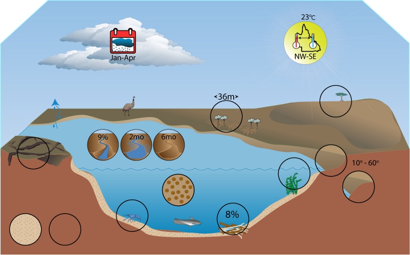 Click on elements of the model or select from the tabs below
The Lake Eyre and Bulloo Freshwater Biogeographic Province (FBP) consists of the Georgina, Diamantina, Cooper Creek, Hay and Bulloo drainage basins, and is located in the south-west of the State. The FBP covers the Channel Country, Mitchell Grass Downs, Northwest Highlands, Desert Uplands, and Mulga Lands vegetation bioregions, and a very small portion of the Brigalow Belt vegetation bioregion. This vast geographic area (greater than 550,000km2) encompasses large variability in climate, geology and hydrology that produce and influence unique ecosystem features at local scales. There are unique topographic and hydrologic features across the FBP. These large dryland river systems have extremely variable flows and their downstream transmission results in extensive floodplain inundation creating vast temporary wetlands. During dry times the riverine system exists as a series of waterholes with variable persistence[1]. The Lake Eyre Basin overlays the Great Artesian Basin, one of the world’s largest aquifer systems. Aquatic ecosystems in the Lake Eyre and Bulloo FBP include ecosystems dependent on surface and groundwater including ephemeral rivers, waterholes, ephemeral wetlands, mound springs and subsurface habitats. The Lake Eyre Basin catchments and the Bulloo catchment are terminal river systems that do not flow to the coast. The Bulloo catchment is a separate river basin with little connectivity between the neighbouring Lake Eyre and Murray Darling Basins. References
Last updated: 22 March 2013 This page should be cited as: Department of Environment, Science and Innovation, Queensland (2013) Queensland Lake Eyre and Bulloo Freshwater Biogeographic Province, WetlandInfo website, accessed 18 March 2024. Available at: https://wetlandinfo.des.qld.gov.au/wetlands/ecology/aquatic-ecosystems-natural/riverine/freshwater-biogeo/lake-eyre-and-bulloo/ |
Site footer

 — Department of Environment, Science and Innovation