Skip links and keyboard navigation

Western Cape and Gulf Freshwater Biogeographic Province

Western Cape and Gulf Freshwater Biogeographic Province – Geology and topography

Wet season (Jan-Mar) Average temperature (25°) Temperature varies along a west east gradient Width of riparian zone (37m) Small trees Grasses Low relief ratio Percentage of water which is base flow (8%) Annual spate duration (1 month) Annual no-flow duration (7 months) Sandstone Clay High macroinvertebrate richness Turbidity variable through region Turbidity variable through region Large woody debris cover (8%) Submerged and emergent macrophyte growth forms dominant Concave bank shape category Convex bank shape category Dominant bank slope (10°-80°) Fauna Fauna

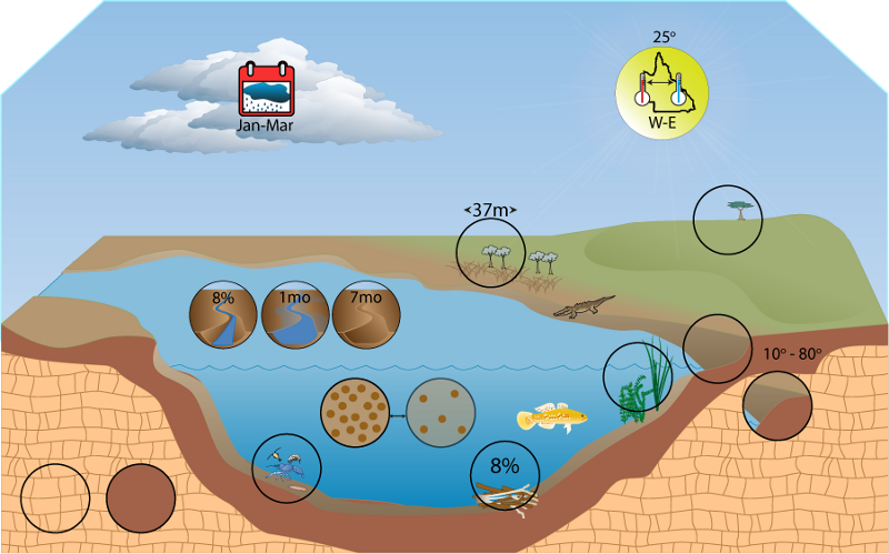
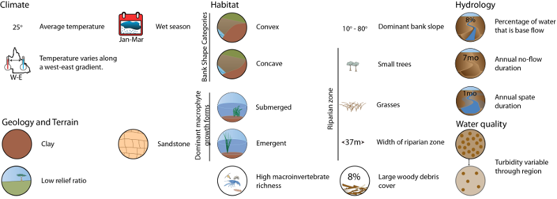
Click on elements of the model or select from the tabs below

Geology

Igneous rocks, Photo by Water Planning Ecology Group, DSITIA

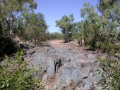
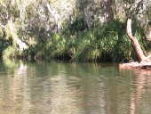
The north and east sections of the FBP are dominated by sandstone; the south is dominated by deep heavy grey and brown cracking clays.  The Australian Natural Resources Atlas[1] has more detailed geological descriptions about the various vegetation bioregions composing the WCG FBP:

  • Cape York Peninsula consists of complex geology dominated by the Torres Strait Volcanics in the north.  South of the region has deeply dissected sandstone plateaus and flat plains of colluvial and alluvial clays, silts, and sands.  West of the region contains extensive sand sheets. 
  • Einasleigh Uplands consists of high ranges and plateau surfaces of palaeozoic sediments, granites, and basalts. The region generally has diverse geology ranging from mesozoic sandstones occurring as small plateaus, alluvium, permian granites palaeozoic sediments, acid volcanics and rugged ranges on folded sediments and igneous rocks.
  • The Mitchell Grass Downs are characterised by undulating downs on shales and limestones.  The soils are predominantly deep heavy grey and brown cracking clays often with self-mulching and sometimes stony surfaces. The plains are interspersed with drainage lines.

Terrain

Relief ratio, Photo by Water Planning Ecology Group, DSITIA

The Western Cape and Gulf has, on average, a low relief ratio, with a mean for the FBP of 0.013. High relief ratio areas are spread throughout the east of the FBP.  Stream segment slope values are also low, with higher values corresponding to areas with high relief ratio values.

The FBP is dominated by the erosional and valley bottom flatness index classes, both of which dominate different regions of the FBP.  A small proportion of the FBP contains ridge top flat areas, which occupy the borders between erosional and valley bottom flat areas.


Terrain

Methods


Mean SE Minimum Maximum
Relief Ratio 0.0133 0.0001 0 0.2719
Stream segment slope (%) 0.8514 0.0047 0 25.4222
Flatness Index class Percentage
Erosional 31
Indeterminate 23
Valley bottom flat 39
Ridge top flat 6

FBP Terrain Map   State Terrain Map


References

  1. ^ ANRA (2002), Australian Natural Resources Atlas. [online], ANRA. Available at: https://data.gov.au/data/dataset/australian-natural-resources-atlas-anra.

Last updated: 22 March 2013

This page should be cited as:

Department of Environment, Science and Innovation, Queensland (2013) Western Cape and Gulf Freshwater Biogeographic Province – Geology and topography, WetlandInfo website, accessed 18 March 2024. Available at: https://wetlandinfo.des.qld.gov.au/wetlands/ecology/aquatic-ecosystems-natural/riverine/freshwater-biogeo/western-cape-and-gulf/geology-topography.html

Queensland Government
WetlandInfo   —   Department of Environment, Science and Innovation