

|
|
South-East Freshwater Biogeographic ProvinceSouth-East Freshwater Biogeographic Province – Geology and topography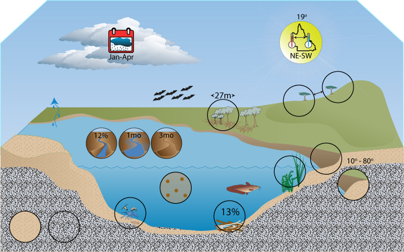 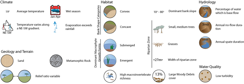 Click on elements of the model or select from the tabs below GeologyThe majority of the FBP consists of the South East Queensland vegetation bioregion, which is characterised by a variety of geology types. The Australian Natural Resources Atlas[1] has more detailed geological descriptions about the various vegetation bioregions composing the SEQ FBP:
TerrainRelief ratio values for the South-East FBP range from low to high, with a mean of 0.03. Low relief values are confined to small patches within the FBP, particularly the coastal and north-western sections of the FBP. The South-East FBP has steep relief in the southern sections of the FBP (foothills of the Great Dividing Range), and to the west of the coast (D’Aguilar, Blackall and Connondale ranges). Stream segment slope values throughout the FBP also range from low to high, with higher values corresponding to areas with higher relief ratio values. The FBP is strongly dominated by erosional flatness index class. Only a small proportion of the FBP contains valley bottom flat areas (in the areas with low relief ratio), and ridge top flat is almost absent. This is likely to result in dominance of coarse bed material in South-East streams and implies a dominance of aquatic assemblages preferring coarser substrate types at the FBP scale. Any biota preferring depositional areas are likely to be restricted in this FBP. The limited extent of valley bottom flats suggests floodplains and the processes associated with floodplain inundation are not likely to be important to the ecology of South-East rivers. The scarcity of depositional areas in the South-East FBP is likely to be associated with the relatively low turbidity of the area and subsequently the widespread distribution of submerged macrophytes. In some sections of the South-East FBP relief is steep and stream slopes are high. In steeper catchments, run-off is generally faster, producing more peaked discharges and greater erosive power[2]. This contributes to high disturbance intensity of spates in these steeper sections of the FBP. In other sections of the FBP, relief is generally shallow and stream slopes are low, contributing to low disturbance intensity of spates in these sections.
FBP Terrain Map State Terrain Map References
Last updated: 22 March 2013 This page should be cited as: Department of Environment, Science and Innovation, Queensland (2013) South-East Freshwater Biogeographic Province – Geology and topography, WetlandInfo website, accessed 18 March 2024. Available at: https://wetlandinfo.des.qld.gov.au/wetlands/ecology/aquatic-ecosystems-natural/riverine/freshwater-biogeo/south-east/geology-topography.html |
Site footer

 — Department of Environment, Science and Innovation