

|
|
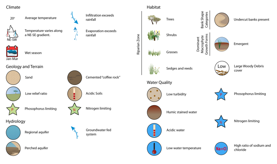
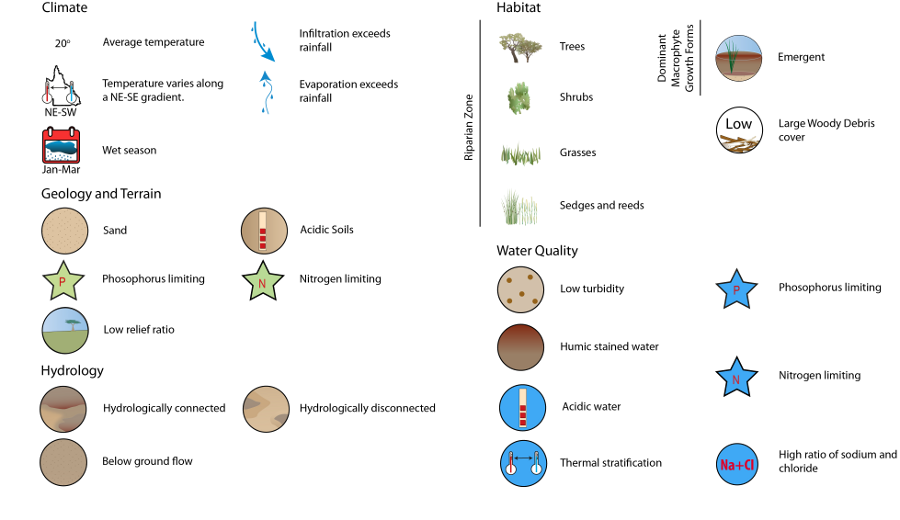
Wallum Freshwater Biogeographic ProvinceWallum Freshwater Biogeographic Province – HabitatClick on elements of the model or select from the tabs below Substrate composition and heterogeneityThe number of substrate classes observed in Wallum FBP is low compared with other FBPs in the state, excepting the Lake Eyre and Bulloo FBP. The edge and macrophyte habitats show the highest number of substrate classes, with means of 2.5 and 2.6 respectively. The pool and run habitats show fewer classes present, with means of 1.7 and 1.8 respectively. Overall, Wallum FBP is dominated by sandy substrate in all habitat types, derived from the dune systems that comprise the region.
Riparian vegetation and macrophytesVegetation surrounding Wallum creeks and streams is dominated by heath, largely composed of grass and small shrubs, with the occasional presence of larger trees. This extends into mixed sclerophyll vegetation in transitional zones and rainforest patches at higher elevations, despite unchanged substrate and water quality characteristics (i.e. Tinana Creek, inland towards Tin Can Bay). As the FBP is generally subject to high rainfall, the majority of vegetation is water-dependent and consequently a definitive riparian zone rarely exists. Species present in these habitats include occasional Melaleuca spp., emergent sedges Lepironia articulata, Eleocharis spp., Baumea spp., and Gahnia spp., and floating macrophytes often display substantial periphyton growth occurring around the stems. MacrophytesMacrophytes have a limited presence in Wallum, largely the result of limited light penetration associated with stained waters. The emergent form is the most common across the FBP, however more variation is observed in the darker chain-of-pond streams, in which both emergent and floating forms occur. Some submerged varieties of macrophyte are found in the region, but are rare.
Perennial streams
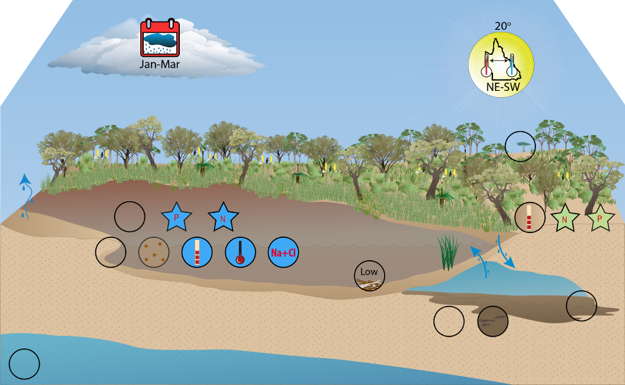
Despite bank steepness varying throughout the region, perennial streams often have undercut banks. Undercut banks result from sandy substrate removal by currents, and bank stability is conferred by the fibrous root matrix of riparian vegetation. These areas provide a refugial habitat under banks for biota, such as benthic organisms, away from the higher energy environments in the stream. In slower flowing runs, gravels and coarse sands are inhabited by invertebrates, but the sediment instability limits algal and aquatic plant colonisation[1]. These coastal streams are generally shallow and constrained by vegetation present at their edges; consequently, their width is often limited. These streams are low-energy, food-limited environments, as the leaf litter in the streams from surrounding vegetation is of poor quality. While woody debris and snags are not dominant features of these streams, where they do exist, they provide important habitat for stream biota. As the riparian vegetation surrounding these waterways is not large, the subsequent woody debris and snags are only the size of regular branches. Chain-of-pond streams
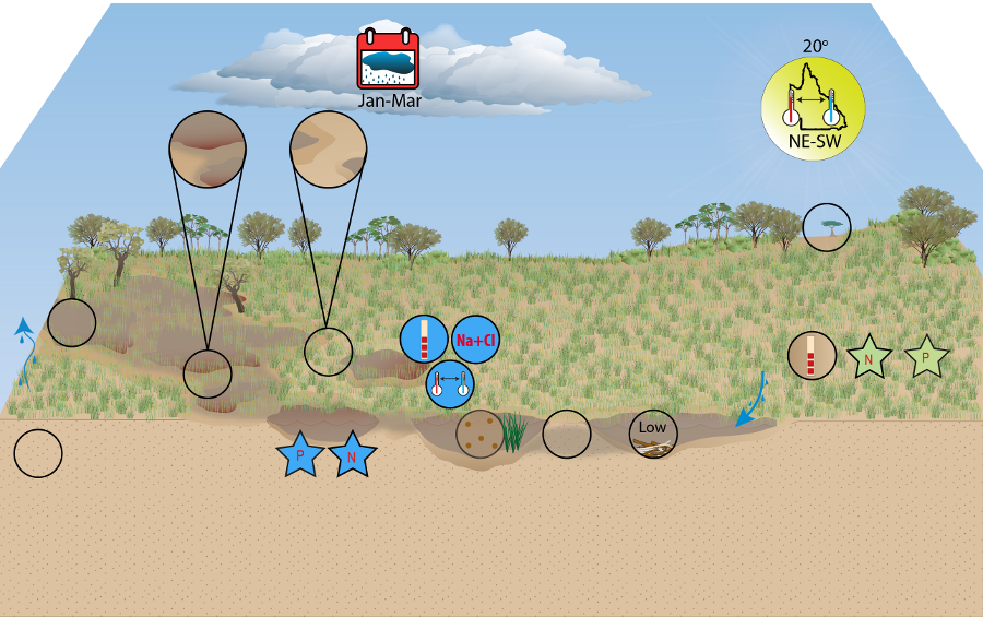
Where flow is present, typically there are no banks in chain-of-pond streams. Conversely, where flow is reduced, the bank forms a gradual incline to become steadily deeper. Typically, as low energy systems, the ponds have a mixture of sandy and peaty substrate, while the interconnecting channels are primarily composed of sand. These waterways exist in the lowland regions of Wallum and typically have darker, more humic stained waters than the perennially flowing streams. These areas tend to be open, poorly shaded systems, with the water displaying thermal stratification in summer due to its long residence time. Riparian vegetation is largely comprised of heath and lacks large trees; consequently, there is little woody debris in the streams. Species present in these habitats include floating macrophytes such as Utricularia sp. and the waterlilies Nymphaea spp. and Nymphoides indica. In addition to these, carnivorous plants such as the sundews Drosera spatulata are characteristic of the area and a function of the low nitrogen environment. These environments provide necessary breeding habitat for the Wallum frog species unique to the area. References
Last updated: 22 March 2013 This page should be cited as: Department of Environment, Science and Innovation, Queensland (2013) Wallum Freshwater Biogeographic Province – Habitat, WetlandInfo website, accessed 18 March 2024. Available at: https://wetlandinfo.des.qld.gov.au/wetlands/ecology/aquatic-ecosystems-natural/riverine/freshwater-biogeo/wallum/habitat.html |
|||||||||||||||||||||||||||||||||||||||||||||||||||||||||||||||||||||||||||||||||||||||||||||||||||||||||||||||||||||||||||||||||||||||||||||||||||||||||||||||||||||||||||||||||||||||||||||||||||||||||||||||||||||||||||||||||||||||||||||||||||||||||||||||||||||||||||||||||||||||||||||||||||||||||||||||||||||||||||||||||||||
Site footer

 — Department of Environment, Science and Innovation