

|
|
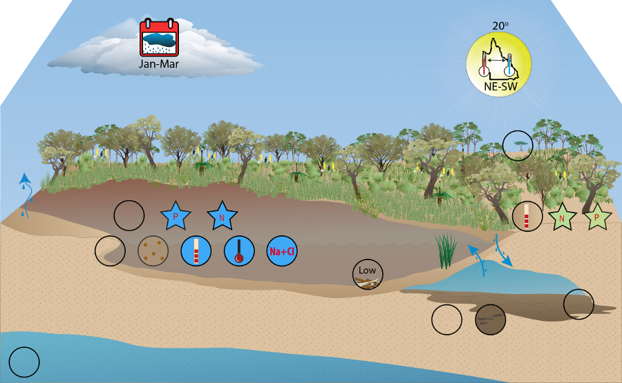
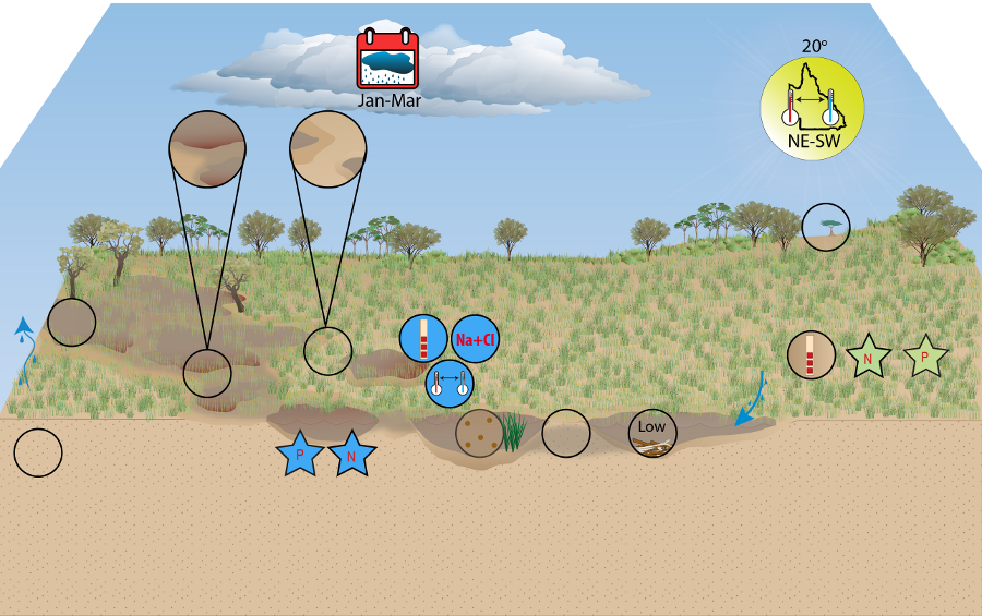
Wallum Freshwater Biogeographic ProvinceWallum Freshwater Biogeographic Province – ClimateClick on elements of the model or select from the tabs below Wallum is characterised by a sub-tropical climate, influenced by its coastal position in the region where overlap between temperate and tropical weather systems occurs[6][7][2]. RainfallAnnual mean precipitation in the FBP is high at 1508 mm per year, making it comparable with the wet FBPs in the north of Queensland. Dominant rainfall is received during the summer months from January to March; however, a small but significant amount is also received during the winter season[7][1]. While consistent precipitation in the region is largely the result of slow-moving and widespread cloud systems, storms also contribute to annual rainfall[1]. The range of mean annual precipitation (minimum to maximum) is relatively small, indicating that rainfall is consistent across the region[4][1]. Wallum has the highest value for mean driest quarter in Queensland at 177 mm, largely a consequence of having a higher minimum value than the other regions. This indicates that moisture availability in this region is comparatively consistent. Mean rainfall erosivity is moderate at 5694 MJ mm ha-1 hr-1 yr-1, with little difference between minimum and maximum values. In comparison with other regions however, high intensity rainfall events, such as summer storms, are likely to have less erosive effect on the FBPs sandy soils.
TemperatureWallum’s mean annual temperature is moderate at 20 °C and is the coolest of the state's coastal regions. Temperature extremes in the region are comparatively mild[1], with a slight gradient of warmer temperatures to the north. The highest weekly mean maximum temperature was consistent across the region, and the lowest mean value in the state. In comparison, the lowest weekly mean minimum temperature was moderate, displaying a slight north-south gradient, with warmer temperatures to the north. The ratio of hottest weekly maximum to coldest weekly minimum indicates only a moderate seasonality in the region, with greater temperature ranges observed further inland.
Water balanceAnnual mean run-off for the region is exceptionally low at 3 mm, displaying a slight north-south gradient, with greater run-off in the southern regions of the FBP. While precipitation largely exceeds evaporation for most of the year[7][6], the dominance of sandy soils in the region results in high infiltration capacity, reducing the run-off associated with rainfall events[5][7][3].
References
Last updated: 22 March 2013 This page should be cited as: Department of Environment, Science and Innovation, Queensland (2013) Wallum Freshwater Biogeographic Province – Climate, WetlandInfo website, accessed 18 March 2024. Available at: https://wetlandinfo.des.qld.gov.au/wetlands/ecology/aquatic-ecosystems-natural/riverine/freshwater-biogeo/wallum/climate.html |
Site footer

 — Department of Environment, Science and Innovation