

|
|
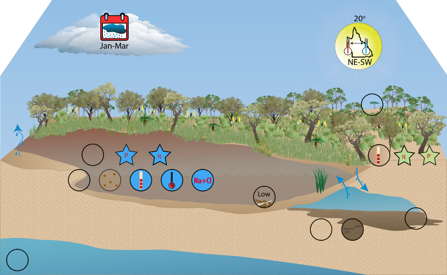
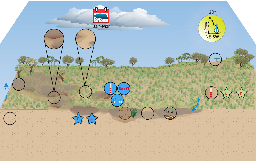
Wallum Freshwater Biogeographic ProvinceWallum Freshwater Biogeographic Province – HydrologyClick on elements of the model or select from the tabs below Little hydrology data has been collected and flow monitoring is minimal. Water systems, both standing and running, are fed from the same water source—regional and perched aquifers[7]. Unconfined bodies of groundwater are present beneath North Stradbroke, Moreton and Bribie islands, and Cooloola-Teewah sand mass on the mainland[7][3]. These regional aquifers are typically located between the Quaternary sand deposits and older bedrock of Wallum islands, characterised by a gentle dome-shape[4]. They are the result of high run-off infiltration into permeable substrates, and the density difference in fresh and sea water creating suppressive forces on the watertable[5][6][7][2]. Perched groundwater is common in the FBP, and the result of impermeable substrate layers (see Geology) inhibiting the downward movement of water, consequently forming an aquifer above the regional groundwater body[4][7][2]. Recharge of regional and perched aquifers is solely reliant on rainfall infiltration, with 30% of rainfall passing to the primary watertable on North Stradbroke Island[5][7][2].
The ground and surface water systems of Wallum FBP are strongly linked in a complex relationship, and often in direct contact[1]. A long-term balance exists between recharge and discharge, with a stable distribution of groundwater as outflow at the coastline, to streams, and in shallow areas of groundwater as evapotranspiration[3]. The constant connection to groundwater in Wallum FBP has led to largely perennial riverine systems. Perennial streams
The perennially available water source buffers the variations in rainfall across seasons, as demonstrated by the Blue Lake Overflow Creek (North Stradbroke Island) hydrograph. Slower water movement and some return seepage to the sand are typical and the result of a sand and vegetation matrix within the streams. Often, over the course of the entire stream length, sections will be gaining water, while others will be losing water. Chain-of-pond streams
Chain-of pond streams represent forms of palustrine wetland, with little overall discharge or velocity. Where connection exists between ponds, flow may occur both above and below ground. These systems are unlikely to be connected to regional or perched aquifers, and are largely rainfall fed. References
Last updated: 22 March 2013 This page should be cited as: Department of Environment, Science and Innovation, Queensland (2013) Wallum Freshwater Biogeographic Province – Hydrology, WetlandInfo website, accessed 18 March 2024. Available at: https://wetlandinfo.des.qld.gov.au/wetlands/ecology/aquatic-ecosystems-natural/riverine/freshwater-biogeo/wallum/hydrology.html |

Site footer

 — Department of Environment, Science and Innovation