

|
|
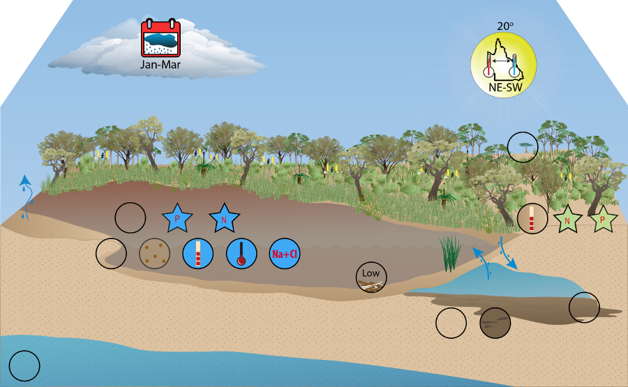
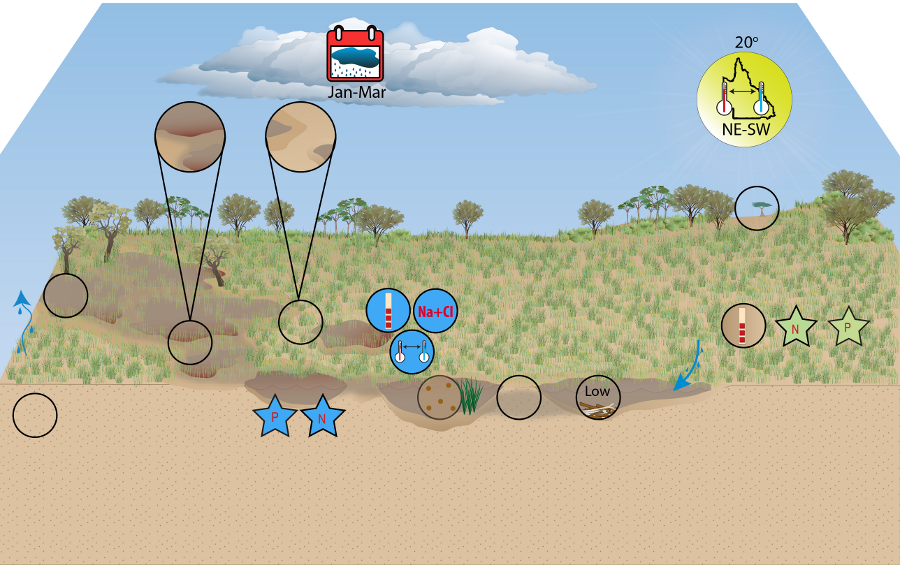
Wallum Freshwater Biogeographic ProvinceWallum Freshwater Biogeographic Province – Water qualityClick on elements of the model or select from the tabs below The water quality of Wallum’s aquatic ecosystems may be considered one of its defining characteristics: largely acidic, nutrient deficient, with low conductivity[5][4]. Water quality assessments in Wallum FBP have predominantly focused on standing water bodies, such as lakes and wetlands. There are notable similarities between the running and standing water systems of Wallum, owing to shared water sources (regional and perched aquifers). Consequently, this research was used to assist the characterisation of Wallum riverine systems. Sandy substrate and limited large riparian vegetation cover in the FBP result in low turbidity, with a mean value of 14 NTU. Water transparency varies across the region, from clear to tannin-stained waters. Transparency in tannin-stained waters is considerably reduced by the presence of dissolved organic acids, largely humic acids derived from leaf litter of the surrounding Melaleuca sp. and Wallum heath[2][3][4][8][1]. The presence of these organic acids is correlated with the lower pH values observed in the FBP[2][3][4][7][8][1]. While the mean pH for the FBP is neutral (7), values range from highly acidic (3.3) to highly alkaline (8.1). The waters of the region are typically low in salinity and conductivity, yet the ionic composition is often similar to sea water[4][8][1]. This dominance of sodium and chloride ions is likely derived from atmospheric supply and is characteristic of weathered coastal environments[6][7][2].
Chain-of-pond streamsThe presence of humic acids is more often associated with chain-of-pond streams, but varies across the region. This variation may be associated with the irregular presence of Melaleuca sp. and heath in riparian vegetation. Thermal stratification often occurs within the chain-of-pond streams, resulting from high residence times of the water. Perennial streamsIn contrast, perennial streams often show lower temperatures than surrounding streams, especially in summer, as they are largely fed from groundwater. They rarely demonstrate thermal stratification owing to their faster flow. References
Last updated: 22 March 2013 This page should be cited as: Department of Environment, Science and Innovation, Queensland (2013) Wallum Freshwater Biogeographic Province – Water quality, WetlandInfo website, accessed 18 March 2024. Available at: https://wetlandinfo.des.qld.gov.au/wetlands/ecology/aquatic-ecosystems-natural/riverine/freshwater-biogeo/wallum/water-quality.html |
Site footer

 — Department of Environment, Science and Innovation