Skip links and keyboard navigation

Central Freshwater Biogeographic Province

Central Freshwater Biogeographic Province – Geology and topography

Wet season (Jan-Apr) Average temperature (22°) Temperature varies along a north south gradient Evaporation exceeds rainfall Width of riparian zone (42m) Small, medium trees Grasses Low relief ratio Phosphorus limiting Percentage of water which is base flow (9%) Annual spate duration (1 month) Annual no-flow duration (4 months) Granite Sandstone Medium macroinvertebrate richness Low turbidity Large woody debris cover (17%) Submerged and emergent macrophyte growth forms dominant Concave bank shape category Convex bank shape category Dominant bank slope (10°-80°) Fauna

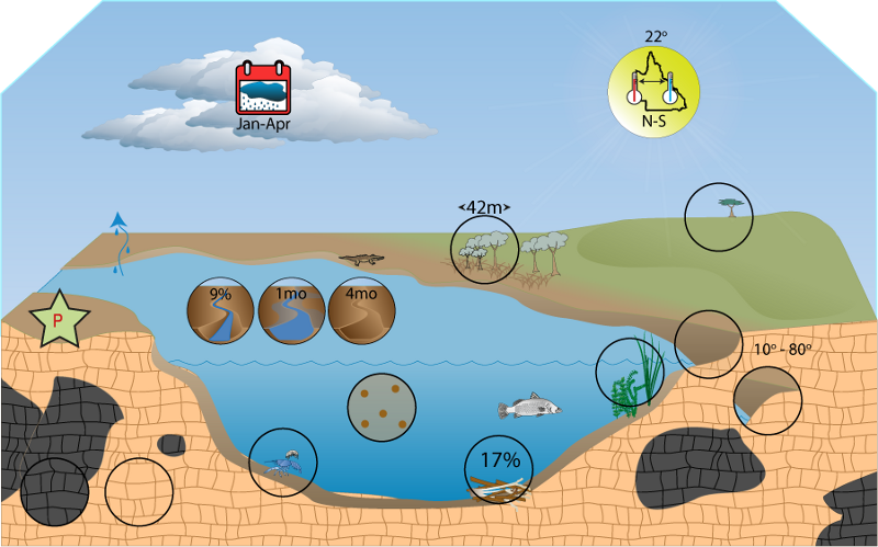
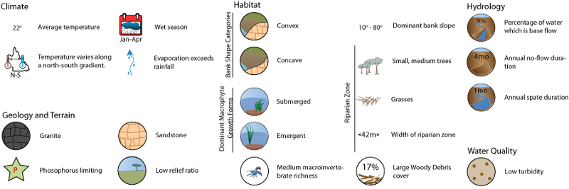
Click on elements of the model or select from the tabs below

Geology

The geology of the FBP is quite diverse, volcanic and sandstone sediments occur frequently.  In general the soils of the FBP have a low fertility the main exception to this is the Central Coast vegetation bioregion.  The Australian Natural Resources Atlas[1] has more detailed geological descriptions about the various vegetation bioregions composing the Central FBP:


  • Brigalow Belt North consists of Permian volcanics and Permian-Triassic sediments of the Bowen and Galilee Basins, Carboniferous and Devonian sediments and volcanics of the Drummond Basin and coastal blocks, Cambrian and Ordovician rocks of the Anakie inlier and associated Tertiary deposits.
  • Einasleigh Uplands consists of high ranges and plateau surfaces of Palaeozoic sediments, granites, and basalts. The region generally has diverse geology ranging from Mesozoic sandstones occurring as small plateaus, alluvium, Permian granites Palaeozoic sediments, acid volcanics and rugged ranges on folded sediments and igneous rocks.
  • The Desert Uplands are broadly defined as consisting of ranges and plains on dissected Tertiary surface and Triassic sandstones. The climate is semi-arid and soils are mostly of poor structure and low fertility. Phosphorous is particularly lacking in most soil types except in the alluvial areas.
  • The Central Mackay Coast consists of fertile alluvial coastal plains.

Terrain

The Central FBP has, on average, a low relief ratio, with a mean for the FBP of 0.02. High relief ratio areas are however spread throughout the FBP and predominate in coastal parts. Stream segment slope values are also on average low, with higher values corresponding to areas with high relief ratio values.

Central FBP is dominated by the erosional flatness index class and erosional areas are spread throughout the FBP. Depositional valley bottom flat areas occur in the western Burdekin and central Fitzroy catchments. Only a small proportion of the FBP contains ridge top flat areas.

Information about terrain

Information about methods

Mean SE Minimum Maximum
Relief Ratio 0.02 0.0001 0 0.30
Stream segment slope (%) 1.45 0.0087 0 31.39
Flatness Index class Percentage
Erosional 63
Indeterminate 9
Valley bottom flat 24
Ridge top flat 4

Summary Maps of FBP Terrain  

State Terrain Map

Information about geology


References

  1. ^ ANRA (2002), Australian Natural Resources Atlas. [online], ANRA. Available at: https://data.gov.au/data/dataset/australian-natural-resources-atlas-anra.

Last updated: 22 March 2013

This page should be cited as:

Department of Environment, Science and Innovation, Queensland (2013) Central Freshwater Biogeographic Province – Geology and topography, WetlandInfo website, accessed 18 March 2024. Available at: https://wetlandinfo.des.qld.gov.au/wetlands/ecology/aquatic-ecosystems-natural/riverine/freshwater-biogeo/central/geology-topography.html

Queensland Government
WetlandInfo   —   Department of Environment, Science and Innovation